You are here: Home > Network List > TA - USArray Transportable Network (new EarthScope stations) Stations List
> Station D12A Red Ives Forest Station, Avery, ID, USA > Earthquake Result Viewer
D12A Red Ives Forest Station, Avery, ID, USA - Earthquake Result Viewer
| Earthquake location: |
Solomon Islands |
| Earthquake latitude/longitude: |
-7.3/155.7 |
| Earthquake time(UTC): |
2007/04/01 (091) 21:11:33 GMT |
| Earthquake Depth: |
10 km |
| Earthquake Magnitude: |
6.3 MB |
| Earthquake Catalog/Contributor: |
WHDF/NEIC |
|
| Network: |
TA USArray Transportable Network (new EarthScope stations) |
| Station: |
D12A Red Ives Forest Station, Avery, ID, USA |
| Lat/Lon: |
47.05 N/115.35 W |
| Elevation: |
1135 m |
|
| Distance: |
94.5 deg |
| Az: |
43.299 deg |
| Baz: |
264.231 deg |
| Ray Param: |
0.041018493 |
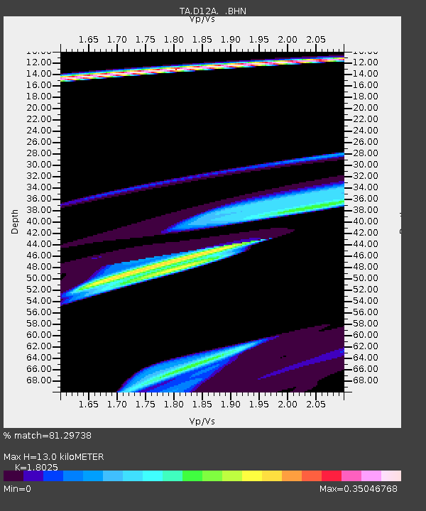
| Estimated Moho Depth: |
13.0 km |
| Estimated Crust Vp/Vs: |
1.80 |
| Assumed Crust Vp: |
6.622 km/s |
| Estimated Crust Vs: |
3.674 km/s |
| Estimated Crust Poisson's Ratio: |
0.28 |
|
| Radial Match: |
81.29738 % |
| Radial Bump: |
400 |
| Transverse Match: |
25.868317 % |
| Transverse Bump: |
370 |
| SOD ConfigId: |
2564 |
| Insert Time: |
2010-03-06 23:57:12.011 +0000 |
| GWidth: |
2.5 |
| Max Bumps: |
400 |
| Tol: |
0.001 |
|

Signal To Noise
| Channel | StoN | STA | LTA |
| TA:D12A: :BHN:20070401T21:24:22.074011Z | 2.0849876 | 2.4553749E-5 | 1.17764475E-5 |
| TA:D12A: :BHE:20070401T21:24:22.074011Z | 0.7754972 | 1.4124985E-5 | 1.8214101E-5 |
| TA:D12A: :BHZ:20070401T21:24:22.074011Z | 1.9378166 | 4.5055753E-5 | 2.3250783E-5 |
| Arrivals |
| Ps | 1.6 SECOND |
| PpPs | 5.4 SECOND |
| PsPs/PpSs | 7.0 SECOND |


