You are here: Home > Network List > TS - TERRAscope (Southern California Seismic Network) Stations List
> Station GSC Goldston, California, USA > Earthquake Result Viewer
GSC Goldston, California, USA - Earthquake Result Viewer
| Earthquake location: |
South Of Mariana Islands |
| Earthquake latitude/longitude: |
13.0/144.8 |
| Earthquake time(UTC): |
1993/08/08 (220) 08:34:25 GMT |
| Earthquake Depth: |
61 km |
| Earthquake Magnitude: |
7.2 MB, 8.1 MS, 8.2 UNKNOWN, 7.5 MW |
| Earthquake Catalog/Contributor: |
WHDF/NEIC |
|
| Network: |
TS TERRAscope (Southern California Seismic Network) |
| Station: |
GSC Goldston, California, USA |
| Lat/Lon: |
35.30 N/116.81 W |
| Elevation: |
990 m |
|
| Distance: |
89.3 deg |
| Az: |
54.016 deg |
| Baz: |
285.333 deg |
| Ray Param: |
0.04181638 |
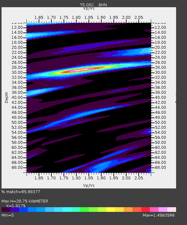
| Estimated Moho Depth: |
28.75 km |
| Estimated Crust Vp/Vs: |
1.82 |
| Assumed Crust Vp: |
6.276 km/s |
| Estimated Crust Vs: |
3.453 km/s |
| Estimated Crust Poisson's Ratio: |
0.28 |
|
| Radial Match: |
95.98377 % |
| Radial Bump: |
400 |
| Transverse Match: |
87.25 % |
| Transverse Bump: |
400 |
| SOD ConfigId: |
16938 |
| Insert Time: |
2010-02-26 14:16:18.624 +0000 |
| GWidth: |
2.5 |
| Max Bumps: |
400 |
| Tol: |
0.001 |
|

Signal To Noise
| Channel | StoN | STA | LTA |
| TS:GSC: :BHN:19930808T08:46:43.536011Z | 1.8799007 | 1.4076146E-7 | 7.487707E-8 |
| TS:GSC: :BHE:19930808T08:46:43.536011Z | 2.932889 | 3.700922E-7 | 1.261869E-7 |
| TS:GSC: :BHZ:19930808T08:46:43.536011Z | 2.837493 | 9.0529784E-7 | 3.190485E-7 |
| Arrivals |
| Ps | 3.8 SECOND |
| PpPs | 13 SECOND |
| PsPs/PpSs | 16 SECOND |


