You are here: Home > Network List > TS - TERRAscope (Southern California Seismic Network) Stations List
> Station GSC Goldston, California, USA > Earthquake Result Viewer
GSC Goldston, California, USA - Earthquake Result Viewer
| Earthquake location: |
Mariana Islands |
| Earthquake latitude/longitude: |
13.1/145.6 |
| Earthquake time(UTC): |
1993/08/11 (223) 14:17:41 GMT |
| Earthquake Depth: |
56 km |
| Earthquake Magnitude: |
6.0 MB, 6.2 MS, 6.1 UNKNOWN, 6.2 MW |
| Earthquake Catalog/Contributor: |
WHDF/NEIC |
|
| Network: |
TS TERRAscope (Southern California Seismic Network) |
| Station: |
GSC Goldston, California, USA |
| Lat/Lon: |
35.30 N/116.81 W |
| Elevation: |
990 m |
|
| Distance: |
88.6 deg |
| Az: |
54.198 deg |
| Baz: |
284.985 deg |
| Ray Param: |
0.04238461 |
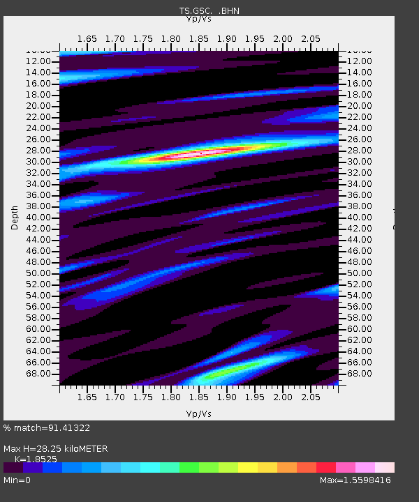
| Estimated Moho Depth: |
28.25 km |
| Estimated Crust Vp/Vs: |
1.85 |
| Assumed Crust Vp: |
6.276 km/s |
| Estimated Crust Vs: |
3.388 km/s |
| Estimated Crust Poisson's Ratio: |
0.29 |
|
| Radial Match: |
91.41322 % |
| Radial Bump: |
400 |
| Transverse Match: |
80.61277 % |
| Transverse Bump: |
400 |
| SOD ConfigId: |
16938 |
| Insert Time: |
2010-02-26 14:16:19.846 +0000 |
| GWidth: |
2.5 |
| Max Bumps: |
400 |
| Tol: |
0.001 |
|

Signal To Noise
| Channel | StoN | STA | LTA |
| TS:GSC: :BHN:19930811T14:29:57.280017Z | 1.5731152 | 1.2411893E-7 | 7.8900094E-8 |
| TS:GSC: :BHE:19930811T14:29:57.280017Z | 1.8918073 | 2.1635165E-7 | 1.14362415E-7 |
| TS:GSC: :BHZ:19930811T14:29:57.278003Z | 1.7488017 | 1.6320162E-7 | 9.332197E-8 |
| Arrivals |
| Ps | 3.9 SECOND |
| PpPs | 13 SECOND |
| PsPs/PpSs | 17 SECOND |


