You are here: Home > Network List > TA - USArray Transportable Network (new EarthScope stations) Stations List
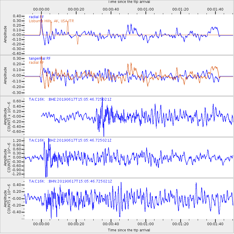
> Station C16K Lisburne Hills, AK, USA > Earthquake Result Viewer
C16K Lisburne Hills, AK, USA - Earthquake Result Viewer
| Earthquake location: |
Sichuan, China |
| Earthquake latitude/longitude: |
28.4/105.0 |
| Earthquake time(UTC): |
2019/06/17 (168) 14:55:45 GMT |
| Earthquake Depth: |
10 km |
| Earthquake Magnitude: |
5.8 Mww |
| Earthquake Catalog/Contributor: |
NEIC PDE/us |
|
| Network: |
TA USArray Transportable Network (new EarthScope stations) |
| Station: |
C16K Lisburne Hills, AK, USA |
| Lat/Lon: |
68.27 N/165.34 W |
| Elevation: |
102 m |
|
| Distance: |
63.8 deg |
| Az: |
24.507 deg |
| Baz: |
281.041 deg |
| Ray Param: |
0.059316754 |
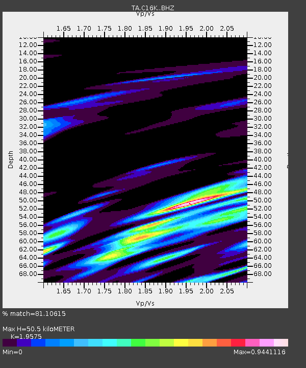
| Estimated Moho Depth: |
50.5 km |
| Estimated Crust Vp/Vs: |
1.96 |
| Assumed Crust Vp: |
5.906 km/s |
| Estimated Crust Vs: |
3.017 km/s |
| Estimated Crust Poisson's Ratio: |
0.32 |
|
| Radial Match: |
81.10615 % |
| Radial Bump: |
400 |
| Transverse Match: |
75.61819 % |
| Transverse Bump: |
400 |
| SOD ConfigId: |
18369291 |
| Insert Time: |
2019-07-01 15:00:03.128 +0000 |
| GWidth: |
2.5 |
| Max Bumps: |
400 |
| Tol: |
0.001 |
|
Signal To Noise
| Channel | StoN | STA | LTA |
| TA:C16K: :BHZ:20190617T15:05:46.725021Z | 6.326969 | 6.1486E-7 | 9.7180816E-8 |
| TA:C16K: :BHN:20190617T15:05:46.725021Z | 1.7790892 | 1.4631705E-7 | 8.224267E-8 |
| TA:C16K: :BHE:20190617T15:05:46.725021Z | 2.3501306 | 2.4440382E-7 | 1.03995845E-7 |
| Arrivals |
| Ps | 8.5 SECOND |
| PpPs | 24 SECOND |
| PsPs/PpSs | 33 SECOND |


