You are here: Home > Network List > TA - USArray Transportable Network (new EarthScope stations) Stations List
> Station D17K Noatak River, AK, USA > Earthquake Result Viewer
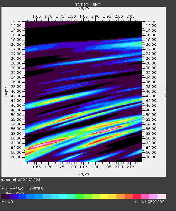
D17K Noatak River, AK, USA - Earthquake Result Viewer
| Earthquake location: |
Sichuan, China |
| Earthquake latitude/longitude: |
28.4/105.0 |
| Earthquake time(UTC): |
2019/06/17 (168) 14:55:45 GMT |
| Earthquake Depth: |
10 km |
| Earthquake Magnitude: |
5.8 Mww |
| Earthquake Catalog/Contributor: |
NEIC PDE/us |
|
| Network: |
TA USArray Transportable Network (new EarthScope stations) |
| Station: |
D17K Noatak River, AK, USA |
| Lat/Lon: |
67.70 N/163.08 W |
| Elevation: |
172 m |
|
| Distance: |
64.8 deg |
| Az: |
24.935 deg |
| Baz: |
283.321 deg |
| Ray Param: |
0.058695637 |
| Estimated Moho Depth: |
63.0 km |
| Estimated Crust Vp/Vs: |
1.65 |
| Assumed Crust Vp: |
6.276 km/s |
| Estimated Crust Vs: |
3.798 km/s |
| Estimated Crust Poisson's Ratio: |
0.21 |
|
| Radial Match: |
82.171326 % |
| Radial Bump: |
400 |
| Transverse Match: |
74.50891 % |
| Transverse Bump: |
400 |
| SOD ConfigId: |
18369291 |
| Insert Time: |
2019-07-01 15:00:07.811 +0000 |
| GWidth: |
2.5 |
| Max Bumps: |
400 |
| Tol: |
0.001 |
|

Signal To Noise
| Channel | StoN | STA | LTA |
| TA:D17K: :BHZ:20190617T15:05:52.975021Z | 5.183977 | 5.09297E-7 | 9.824445E-8 |
| TA:D17K: :BHN:20190617T15:05:52.975021Z | 1.7969991 | 9.5526644E-8 | 5.3158985E-8 |
| TA:D17K: :BHE:20190617T15:05:52.975021Z | 2.4401467 | 1.9243436E-7 | 7.88618E-8 |
| Arrivals |
| Ps | 6.8 SECOND |
| PpPs | 26 SECOND |
| PsPs/PpSs | 32 SECOND |


