You are here: Home > Network List > TA - USArray Transportable Network (new EarthScope stations) Stations List
> Station D22K Ayikyak River, AK, USA > Earthquake Result Viewer
D22K Ayikyak River, AK, USA - Earthquake Result Viewer
| Earthquake location: |
Sichuan, China |
| Earthquake latitude/longitude: |
28.4/105.0 |
| Earthquake time(UTC): |
2019/06/17 (168) 14:55:45 GMT |
| Earthquake Depth: |
10 km |
| Earthquake Magnitude: |
5.8 Mww |
| Earthquake Catalog/Contributor: |
NEIC PDE/us |
|
| Network: |
TA USArray Transportable Network (new EarthScope stations) |
| Station: |
D22K Ayikyak River, AK, USA |
| Lat/Lon: |
68.88 N/152.68 W |
| Elevation: |
532 m |
|
| Distance: |
68.1 deg |
| Az: |
22.428 deg |
| Baz: |
291.977 deg |
| Ray Param: |
0.05651375 |
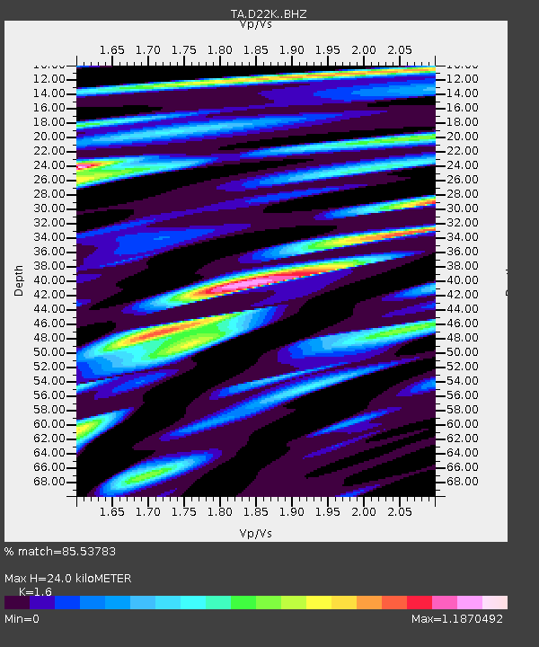
| Estimated Moho Depth: |
24.0 km |
| Estimated Crust Vp/Vs: |
1.60 |
| Assumed Crust Vp: |
6.221 km/s |
| Estimated Crust Vs: |
3.888 km/s |
| Estimated Crust Poisson's Ratio: |
0.18 |
|
| Radial Match: |
85.53783 % |
| Radial Bump: |
400 |
| Transverse Match: |
88.8714 % |
| Transverse Bump: |
400 |
| SOD ConfigId: |
18369291 |
| Insert Time: |
2019-07-01 15:00:09.802 +0000 |
| GWidth: |
2.5 |
| Max Bumps: |
400 |
| Tol: |
0.001 |
|

Signal To Noise
| Channel | StoN | STA | LTA |
| TA:D22K: :BHZ:20190617T15:06:14.199997Z | 3.3080652 | 7.9183604E-7 | 2.393653E-7 |
| TA:D22K: :BHN:20190617T15:06:14.199997Z | 0.896103 | 1.5386001E-7 | 1.7169903E-7 |
| TA:D22K: :BHE:20190617T15:06:14.199997Z | 2.007117 | 3.3419093E-7 | 1.6650296E-7 |
| Arrivals |
| Ps | 2.4 SECOND |
| PpPs | 9.6 SECOND |
| PsPs/PpSs | 12 SECOND |


