You are here: Home > Network List > TA - USArray Transportable Network (new EarthScope stations) Stations List
> Station E21K Killik River, AK, USA > Earthquake Result Viewer
E21K Killik River, AK, USA - Earthquake Result Viewer
| Earthquake location: |
Sichuan, China |
| Earthquake latitude/longitude: |
28.4/105.0 |
| Earthquake time(UTC): |
2019/06/17 (168) 14:55:45 GMT |
| Earthquake Depth: |
10 km |
| Earthquake Magnitude: |
5.8 Mww |
| Earthquake Catalog/Contributor: |
NEIC PDE/us |
|
| Network: |
TA USArray Transportable Network (new EarthScope stations) |
| Station: |
E21K Killik River, AK, USA |
| Lat/Lon: |
68.44 N/153.97 W |
| Elevation: |
653 m |
|
| Distance: |
67.8 deg |
| Az: |
23.057 deg |
| Baz: |
291.012 deg |
| Ray Param: |
0.05669487 |
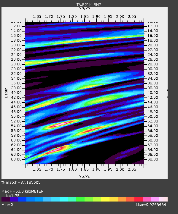
| Estimated Moho Depth: |
53.0 km |
| Estimated Crust Vp/Vs: |
1.75 |
| Assumed Crust Vp: |
6.221 km/s |
| Estimated Crust Vs: |
3.555 km/s |
| Estimated Crust Poisson's Ratio: |
0.26 |
|
| Radial Match: |
87.185005 % |
| Radial Bump: |
400 |
| Transverse Match: |
81.9987 % |
| Transverse Bump: |
400 |
| SOD ConfigId: |
18369291 |
| Insert Time: |
2019-07-01 15:00:14.903 +0000 |
| GWidth: |
2.5 |
| Max Bumps: |
400 |
| Tol: |
0.001 |
|

Signal To Noise
| Channel | StoN | STA | LTA |
| TA:E21K: :BHZ:20190617T15:06:12.449997Z | 5.6430187 | 7.125804E-7 | 1.2627646E-7 |
| TA:E21K: :BHN:20190617T15:06:12.449997Z | 1.5027064 | 1.1374972E-7 | 7.569657E-8 |
| TA:E21K: :BHE:20190617T15:06:12.449997Z | 3.4873013 | 2.469309E-7 | 7.0808596E-8 |
| Arrivals |
| Ps | 6.6 SECOND |
| PpPs | 23 SECOND |
| PsPs/PpSs | 29 SECOND |


