You are here: Home > Network List > BK - Berkeley Digital Seismograph Network Stations List
> Station MCCM Marconi Conference Center, Marshall, CA, USA > Earthquake Result Viewer
MCCM Marconi Conference Center, Marshall, CA, USA - Earthquake Result Viewer
| Earthquake location: |
Near East Coast Of Honshu, Japan |
| Earthquake latitude/longitude: |
37.4/141.4 |
| Earthquake time(UTC): |
2016/11/21 (326) 20:59:49 GMT |
| Earthquake Depth: |
11 km |
| Earthquake Magnitude: |
6.9 MWB, 7.3 MI |
| Earthquake Catalog/Contributor: |
NEIC PDE/NEIC COMCAT |
|
| Network: |
BK Berkeley Digital Seismograph Network |
| Station: |
MCCM Marconi Conference Center, Marshall, CA, USA |
| Lat/Lon: |
38.14 N/122.88 W |
| Elevation: |
-7.7 m |
|
| Distance: |
72.0 deg |
| Az: |
55.59 deg |
| Baz: |
303.552 deg |
| Ray Param: |
0.05396415 |
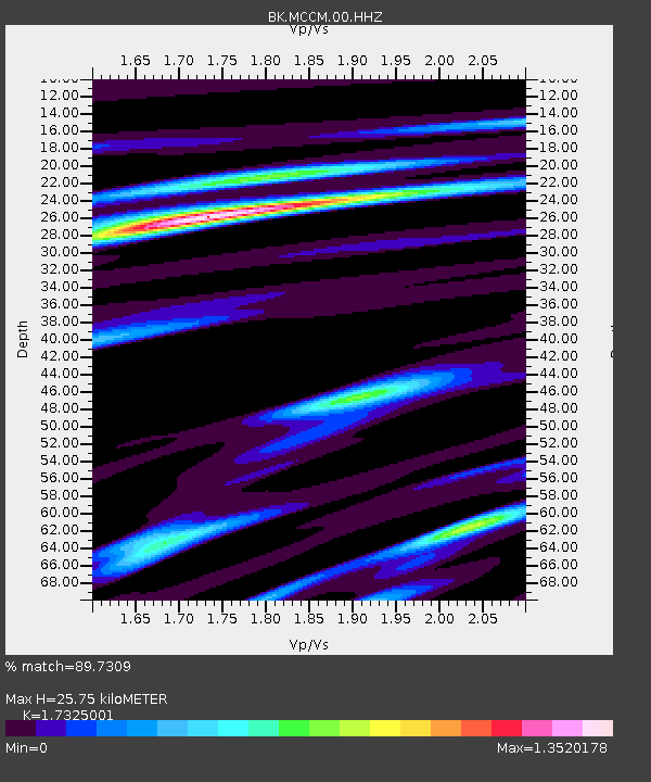
| Estimated Moho Depth: |
25.75 km |
| Estimated Crust Vp/Vs: |
1.73 |
| Assumed Crust Vp: |
6.472 km/s |
| Estimated Crust Vs: |
3.736 km/s |
| Estimated Crust Poisson's Ratio: |
0.25 |
|
| Radial Match: |
89.7309 % |
| Radial Bump: |
400 |
| Transverse Match: |
70.04184 % |
| Transverse Bump: |
400 |
| SOD ConfigId: |
1858631 |
| Insert Time: |
2016-12-05 21:00:44.785 +0000 |
| GWidth: |
2.5 |
| Max Bumps: |
400 |
| Tol: |
0.001 |
|

Signal To Noise
| Channel | StoN | STA | LTA |
| BK:MCCM:00:HHZ:20161121T21:10:41.187979Z | 2.2062998 | 1.4398701E-6 | 6.526176E-7 |
| BK:MCCM:00:HHN:20161121T21:10:41.187979Z | 1.3150152 | 9.201776E-7 | 6.9974675E-7 |
| BK:MCCM:00:HHE:20161121T21:10:41.187979Z | 1.2017194 | 8.340845E-7 | 6.9407594E-7 |
| Arrivals |
| Ps | 3.0 SECOND |
| PpPs | 10 SECOND |
| PsPs/PpSs | 14 SECOND |


