You are here: Home > Network List > TA - USArray Transportable Network (new EarthScope stations) Stations List
> Station D12A Red Ives Forest Station, Avery, ID, USA > Earthquake Result Viewer
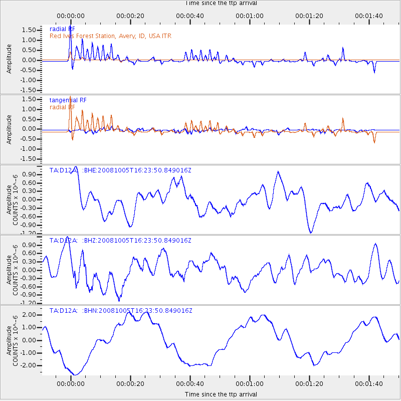
D12A Red Ives Forest Station, Avery, ID, USA - Earthquake Result Viewer
*The percent match for this event was below the threshold and hence no stack was calculated.
| Earthquake location: |
Tajikistan-Xinjiang Border Reg. |
| Earthquake latitude/longitude: |
39.5/73.9 |
| Earthquake time(UTC): |
2008/10/05 (279) 16:11:10 GMT |
| Earthquake Depth: |
35 km |
| Earthquake Magnitude: |
5.6 MB |
| Earthquake Catalog/Contributor: |
WHDF/NEIC |
|
| Network: |
TA USArray Transportable Network (new EarthScope stations) |
| Station: |
D12A Red Ives Forest Station, Avery, ID, USA |
| Lat/Lon: |
47.05 N/115.35 W |
| Elevation: |
1135 m |
|
| Distance: |
93.4 deg |
| Az: |
6.315 deg |
| Baz: |
352.851 deg |
| Ray Param: |
$rayparam |
*The percent match for this event was below the threshold and hence was not used in the summary stack. |
|
| Radial Match: |
68.52075 % |
| Radial Bump: |
262 |
| Transverse Match: |
55.189438 % |
| Transverse Bump: |
375 |
| SOD ConfigId: |
2560 |
| Insert Time: |
2010-03-06 23:58:34.615 +0000 |
| GWidth: |
2.5 |
| Max Bumps: |
400 |
| Tol: |
0.001 |
|
Signal To Noise
| Channel | StoN | STA | LTA |
| TA:D12A: :BHZ:20081005T16:23:50.849016Z | 1.1850907 | 5.2964646E-7 | 4.4692482E-7 |
| TA:D12A: :BHN:20081005T16:23:50.849016Z | 2.7905939 | 2.9348646E-6 | 1.051699E-6 |
| TA:D12A: :BHE:20081005T16:23:50.849016Z | 0.8760628 | 4.6099953E-7 | 5.2621743E-7 |
| Arrivals |
| Ps | |
| PpPs | |
| PsPs/PpSs | |


