You are here: Home > Network List > TA - USArray Transportable Network (new EarthScope stations) Stations List
> Station O15K Ungalikthiuk River, AK, USA > Earthquake Result Viewer
O15K Ungalikthiuk River, AK, USA - Earthquake Result Viewer
| Earthquake location: |
Sichuan, China |
| Earthquake latitude/longitude: |
28.4/105.0 |
| Earthquake time(UTC): |
2019/06/17 (168) 14:55:45 GMT |
| Earthquake Depth: |
10 km |
| Earthquake Magnitude: |
5.8 Mww |
| Earthquake Catalog/Contributor: |
NEIC PDE/us |
|
| Network: |
TA USArray Transportable Network (new EarthScope stations) |
| Station: |
O15K Ungalikthiuk River, AK, USA |
| Lat/Lon: |
59.18 N/159.82 W |
| Elevation: |
306 m |
|
| Distance: |
68.6 deg |
| Az: |
33.413 deg |
| Baz: |
289.599 deg |
| Ray Param: |
0.056179196 |
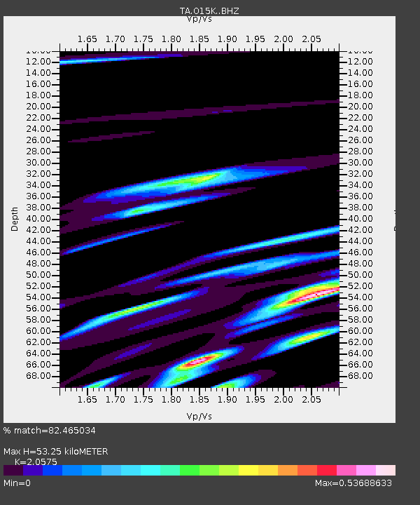
| Estimated Moho Depth: |
53.25 km |
| Estimated Crust Vp/Vs: |
2.06 |
| Assumed Crust Vp: |
6.24 km/s |
| Estimated Crust Vs: |
3.033 km/s |
| Estimated Crust Poisson's Ratio: |
0.35 |
|
| Radial Match: |
82.465034 % |
| Radial Bump: |
400 |
| Transverse Match: |
82.71135 % |
| Transverse Bump: |
400 |
| SOD ConfigId: |
18369291 |
| Insert Time: |
2019-07-01 15:01:10.453 +0000 |
| GWidth: |
2.5 |
| Max Bumps: |
400 |
| Tol: |
0.001 |
|

Signal To Noise
| Channel | StoN | STA | LTA |
| TA:O15K: :BHZ:20190617T15:06:17.400009Z | 5.075593 | 5.664775E-7 | 1.11608145E-7 |
| TA:O15K: :BHN:20190617T15:06:17.400009Z | 1.0179473 | 9.488034E-8 | 9.320751E-8 |
| TA:O15K: :BHE:20190617T15:06:17.400009Z | 1.7589203 | 2.137829E-7 | 1.2154212E-7 |
| Arrivals |
| Ps | 9.3 SECOND |
| PpPs | 25 SECOND |
| PsPs/PpSs | 35 SECOND |


