You are here: Home > Network List > TA - USArray Transportable Network (new EarthScope stations) Stations List
> Station D12A Red Ives Forest Station, Avery, ID, USA > Earthquake Result Viewer
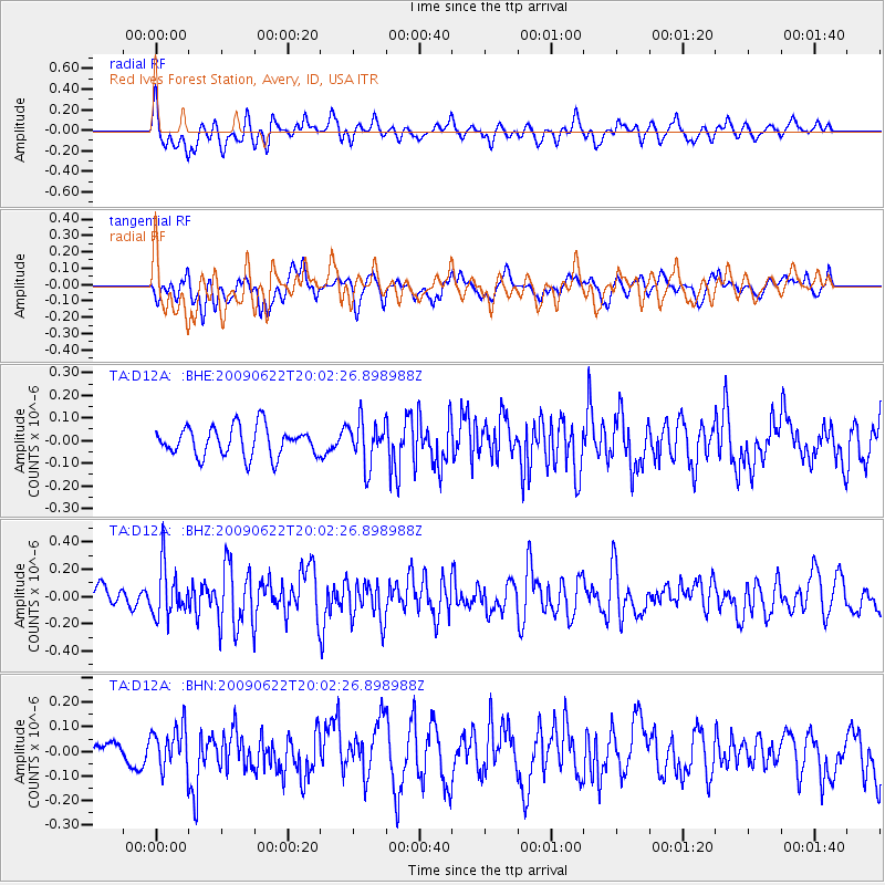
D12A Red Ives Forest Station, Avery, ID, USA - Earthquake Result Viewer
*The percent match for this event was below the threshold and hence no stack was calculated.
| Earthquake location: |
Andreanof Islands, Aleutian Is. |
| Earthquake latitude/longitude: |
51.3/-178.2 |
| Earthquake time(UTC): |
2009/06/22 (173) 19:55:24 GMT |
| Earthquake Depth: |
35 km |
| Earthquake Magnitude: |
5.6 MB, 5.6 MW, 5.6 MW |
| Earthquake Catalog/Contributor: |
WHDF/NEIC |
|
| Network: |
TA USArray Transportable Network (new EarthScope stations) |
| Station: |
D12A Red Ives Forest Station, Avery, ID, USA |
| Lat/Lon: |
47.05 N/115.35 W |
| Elevation: |
1135 m |
|
| Distance: |
40.2 deg |
| Az: |
70.494 deg |
| Baz: |
300.017 deg |
| Ray Param: |
$rayparam |
*The percent match for this event was below the threshold and hence was not used in the summary stack. |
|
| Radial Match: |
60.20855 % |
| Radial Bump: |
400 |
| Transverse Match: |
54.747055 % |
| Transverse Bump: |
400 |
| SOD ConfigId: |
2648 |
| Insert Time: |
2010-03-06 23:59:04.652 +0000 |
| GWidth: |
2.5 |
| Max Bumps: |
400 |
| Tol: |
0.001 |
|
Signal To Noise
| Channel | StoN | STA | LTA |
| TA:D12A: :BHZ:20090622T20:02:26.898988Z | 3.2337892 | 1.8233885E-7 | 5.638551E-8 |
| TA:D12A: :BHN:20090622T20:02:26.898988Z | 2.125192 | 8.629351E-8 | 4.0605045E-8 |
| TA:D12A: :BHE:20090622T20:02:26.898988Z | 1.4886947 | 9.602739E-8 | 6.450443E-8 |
| Arrivals |
| Ps | |
| PpPs | |
| PsPs/PpSs | |


