You are here: Home > Network List > TS - TERRAscope (Southern California Seismic Network) Stations List
> Station GSC Goldston, California, USA > Earthquake Result Viewer
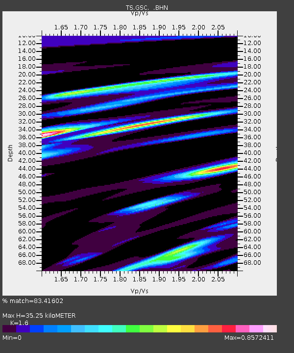
GSC Goldston, California, USA - Earthquake Result Viewer
| Earthquake location: |
Western Brazil |
| Earthquake latitude/longitude: |
-8.5/-71.5 |
| Earthquake time(UTC): |
1993/05/06 (126) 13:03:19 GMT |
| Earthquake Depth: |
586 km |
| Earthquake Magnitude: |
5.8 MB, 5.8 UNKNOWN |
| Earthquake Catalog/Contributor: |
WHDF/NEIC |
|
| Network: |
TS TERRAscope (Southern California Seismic Network) |
| Station: |
GSC Goldston, California, USA |
| Lat/Lon: |
35.30 N/116.81 W |
| Elevation: |
990 m |
|
| Distance: |
61.0 deg |
| Az: |
318.324 deg |
| Baz: |
126.469 deg |
| Ray Param: |
0.058859624 |
| Estimated Moho Depth: |
35.25 km |
| Estimated Crust Vp/Vs: |
1.60 |
| Assumed Crust Vp: |
6.276 km/s |
| Estimated Crust Vs: |
3.922 km/s |
| Estimated Crust Poisson's Ratio: |
0.18 |
|
| Radial Match: |
83.41602 % |
| Radial Bump: |
400 |
| Transverse Match: |
80.48491 % |
| Transverse Bump: |
400 |
| SOD ConfigId: |
17000 |
| Insert Time: |
2010-02-26 14:16:25.590 +0000 |
| GWidth: |
2.5 |
| Max Bumps: |
400 |
| Tol: |
0.001 |
|

Signal To Noise
| Channel | StoN | STA | LTA |
| TS:GSC: :BHN:19930506T13:12:06.055005Z | 1.9311819 | 4.825859E-7 | 2.4989149E-7 |
| TS:GSC: :BHE:19930506T13:12:06.055005Z | 5.893192 | 8.057157E-7 | 1.3671973E-7 |
| TS:GSC: :BHZ:19930506T13:12:06.055005Z | 8.0836315 | 2.1189574E-6 | 2.6212936E-7 |
| Arrivals |
| Ps | 3.5 SECOND |
| PpPs | 14 SECOND |
| PsPs/PpSs | 17 SECOND |


