You are here: Home > Network List > TA - USArray Transportable Network (new EarthScope stations) Stations List
> Station D12A Red Ives Forest Station, Avery, ID, USA > Earthquake Result Viewer
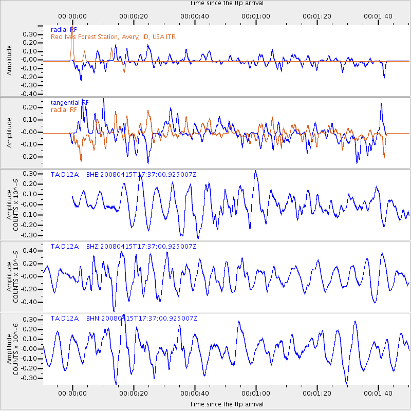
D12A Red Ives Forest Station, Avery, ID, USA - Earthquake Result Viewer
*The percent match for this event was below the threshold and hence no stack was calculated.
| Earthquake location: |
Tonga Islands |
| Earthquake latitude/longitude: |
-18.7/-176.0 |
| Earthquake time(UTC): |
2008/04/15 (106) 17:24:56 GMT |
| Earthquake Depth: |
10 km |
| Earthquake Magnitude: |
5.5 MB, 5.5 MS, 5.7 MW, 5.6 MW |
| Earthquake Catalog/Contributor: |
WHDF/NEIC |
|
| Network: |
TA USArray Transportable Network (new EarthScope stations) |
| Station: |
D12A Red Ives Forest Station, Avery, ID, USA |
| Lat/Lon: |
47.05 N/115.35 W |
| Elevation: |
1135 m |
|
| Distance: |
85.1 deg |
| Az: |
36.723 deg |
| Baz: |
235.986 deg |
| Ray Param: |
$rayparam |
*The percent match for this event was below the threshold and hence was not used in the summary stack. |
|
| Radial Match: |
57.171677 % |
| Radial Bump: |
400 |
| Transverse Match: |
45.76798 % |
| Transverse Bump: |
400 |
| SOD ConfigId: |
2504 |
| Insert Time: |
2010-03-06 23:59:29.094 +0000 |
| GWidth: |
2.5 |
| Max Bumps: |
400 |
| Tol: |
0.001 |
|
Signal To Noise
| Channel | StoN | STA | LTA |
| TA:D12A: :BHZ:20080415T17:37:00.925007Z | 0.7705928 | 9.521085E-8 | 1.2355532E-7 |
| TA:D12A: :BHN:20080415T17:37:00.925007Z | 0.8241191 | 1.0388054E-7 | 1.260504E-7 |
| TA:D12A: :BHE:20080415T17:37:00.925007Z | 1.0380645 | 1.1479576E-7 | 1.1058634E-7 |
| Arrivals |
| Ps | |
| PpPs | |
| PsPs/PpSs | |


