You are here: Home > Network List > GS - US Geological Survey Networks Stations List
> Station OK025 Westminster Rd and Hefner Rd, NE Oklahoma City, Oklahoma, U. > Earthquake Result Viewer
OK025 Westminster Rd and Hefner Rd, NE Oklahoma City, Oklahoma, U. - Earthquake Result Viewer

| Earthquake location: |
Near East Coast Of Honshu, Japan |
| Earthquake latitude/longitude: |
37.4/141.4 |
| Earthquake time(UTC): |
2016/11/21 (326) 20:59:49 GMT |
| Earthquake Depth: |
11 km |
| Earthquake Magnitude: |
6.9 MWB, 7.3 MI |
| Earthquake Catalog/Contributor: |
NEIC PDE/NEIC COMCAT |
|
| Network: |
GS US Geological Survey Networks |
| Station: |
OK025 Westminster Rd and Hefner Rd, NE Oklahoma City, Oklahoma, U. |
| Lat/Lon: |
35.58 N/97.34 W |
| Elevation: |
348 m |
|
| Distance: |
89.2 deg |
| Az: |
44.176 deg |
| Baz: |
317.086 deg |
| Ray Param: |
0.041997 |
| Estimated Moho Depth: |
12.25 km |
| Estimated Crust Vp/Vs: |
1.83 |
| Assumed Crust Vp: |
6.426 km/s |
| Estimated Crust Vs: |
3.512 km/s |
| Estimated Crust Poisson's Ratio: |
0.29 |
|
| Radial Match: |
92.43383 % |
| Radial Bump: |
400 |
| Transverse Match: |
76.72083 % |
| Transverse Bump: |
400 |
| SOD ConfigId: |
1858631 |
| Insert Time: |
2016-12-05 21:01:43.852 +0000 |
| GWidth: |
2.5 |
| Max Bumps: |
400 |
| Tol: |
0.001 |
|
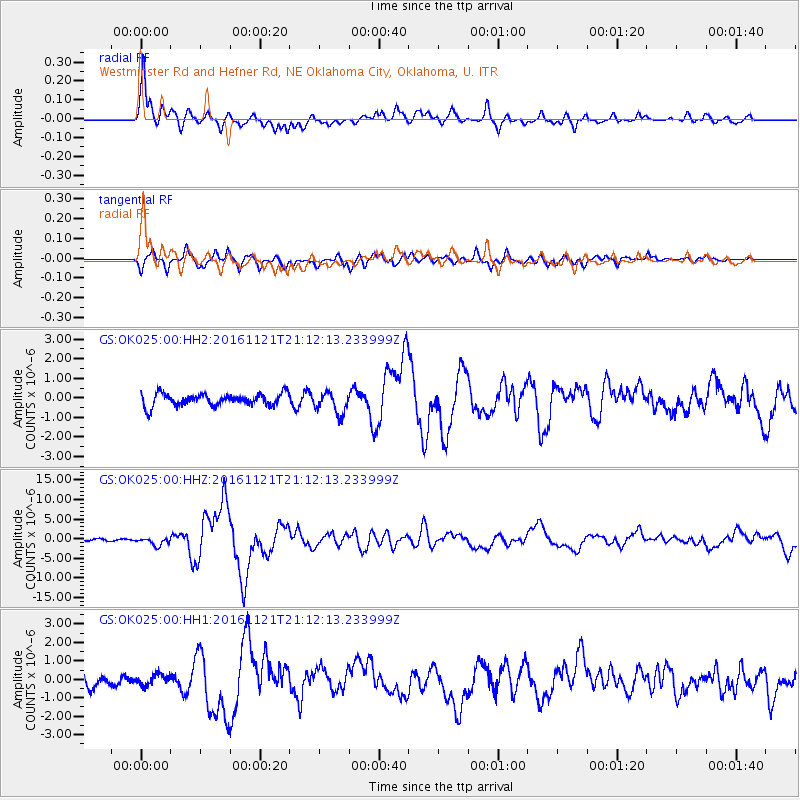
Signal To Noise
| Channel | StoN | STA | LTA |
| GS:OK025:00:HHZ:20161121T21:12:13.233999Z | 4.5851307 | 1.0323878E-6 | 2.2515995E-7 |
| GS:OK025:00:HH1:20161121T21:12:13.233999Z | 0.78746367 | 2.9094048E-7 | 3.6946525E-7 |
| GS:OK025:00:HH2:20161121T21:12:13.233999Z | 1.8028231 | 5.5287774E-7 | 3.0667331E-7 |
| Arrivals |
| Ps | 1.6 SECOND |
| PpPs | 5.3 SECOND |
| PsPs/PpSs | 6.9 SECOND |


