You are here: Home > Network List > GS - US Geological Survey Networks Stations List
> Station OK031 2598 S. Brethren Rd., Cushing, OK, USA > Earthquake Result Viewer
OK031 2598 S. Brethren Rd., Cushing, OK, USA - Earthquake Result Viewer
| Earthquake location: |
Near East Coast Of Honshu, Japan |
| Earthquake latitude/longitude: |
37.4/141.4 |
| Earthquake time(UTC): |
2016/11/21 (326) 20:59:49 GMT |
| Earthquake Depth: |
11 km |
| Earthquake Magnitude: |
6.9 MWB, 7.3 MI |
| Earthquake Catalog/Contributor: |
NEIC PDE/NEIC COMCAT |
|
| Network: |
GS US Geological Survey Networks |
| Station: |
OK031 2598 S. Brethren Rd., Cushing, OK, USA |
| Lat/Lon: |
35.95 N/96.84 W |
| Elevation: |
290 m |
|
| Distance: |
89.2 deg |
| Az: |
43.626 deg |
| Baz: |
317.369 deg |
| Ray Param: |
0.041994818 |
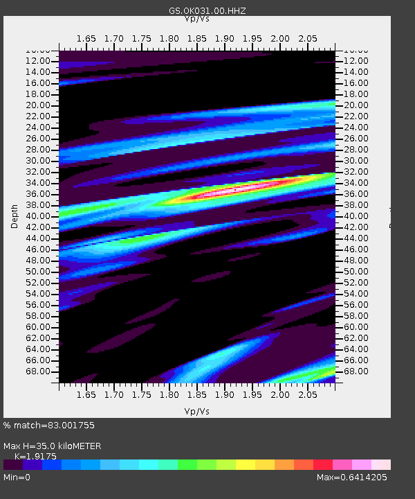
| Estimated Moho Depth: |
35.0 km |
| Estimated Crust Vp/Vs: |
1.92 |
| Assumed Crust Vp: |
6.426 km/s |
| Estimated Crust Vs: |
3.351 km/s |
| Estimated Crust Poisson's Ratio: |
0.31 |
|
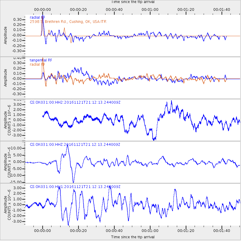
| Radial Match: |
83.001755 % |
| Radial Bump: |
400 |
| Transverse Match: |
63.71068 % |
| Transverse Bump: |
400 |
| SOD ConfigId: |
1858631 |
| Insert Time: |
2016-12-05 21:01:48.341 +0000 |
| GWidth: |
2.5 |
| Max Bumps: |
400 |
| Tol: |
0.001 |
|
Signal To Noise
| Channel | StoN | STA | LTA |
| GS:OK031:00:HHZ:20161121T21:12:13.244009Z | 5.624975 | 7.8145086E-7 | 1.389252E-7 |
| GS:OK031:00:HH1:20161121T21:12:13.244009Z | 0.89627224 | 5.2589445E-7 | 5.8675755E-7 |
| GS:OK031:00:HH2:20161121T21:12:13.244009Z | 0.73004377 | 5.6124554E-7 | 7.687835E-7 |
| Arrivals |
| Ps | 5.1 SECOND |
| PpPs | 16 SECOND |
| PsPs/PpSs | 21 SECOND |


