You are here: Home > Network List > TA - USArray Transportable Network (new EarthScope stations) Stations List
> Station D12A Red Ives Forest Station, Avery, ID, USA > Earthquake Result Viewer
D12A Red Ives Forest Station, Avery, ID, USA - Earthquake Result Viewer
*The percent match for this event was below the threshold and hence no stack was calculated.
| Earthquake location: |
Mariana Islands |
| Earthquake latitude/longitude: |
16.4/146.9 |
| Earthquake time(UTC): |
2008/08/14 (227) 00:06:40 GMT |
| Earthquake Depth: |
53 km |
| Earthquake Magnitude: |
5.5 MB, 4.8 MS |
| Earthquake Catalog/Contributor: |
WHDF/NEIC |
|
| Network: |
TA USArray Transportable Network (new EarthScope stations) |
| Station: |
D12A Red Ives Forest Station, Avery, ID, USA |
| Lat/Lon: |
47.05 N/115.35 W |
| Elevation: |
1135 m |
|
| Distance: |
83.3 deg |
| Az: |
43.021 deg |
| Baz: |
286.752 deg |
| Ray Param: |
$rayparam |
*The percent match for this event was below the threshold and hence was not used in the summary stack. |
|
| Radial Match: |
54.698013 % |
| Radial Bump: |
400 |
| Transverse Match: |
53.44843 % |
| Transverse Bump: |
400 |
| SOD ConfigId: |
2504 |
| Insert Time: |
2010-03-06 23:59:40.176 +0000 |
| GWidth: |
2.5 |
| Max Bumps: |
400 |
| Tol: |
0.001 |
|
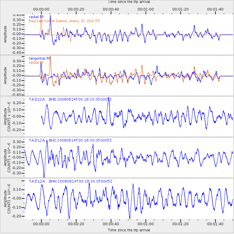
Signal To Noise
| Channel | StoN | STA | LTA |
| TA:D12A: :BHZ:20080814T00:18:30.050005Z | 2.2289941 | 1.8951398E-7 | 8.5022194E-8 |
| TA:D12A: :BHN:20080814T00:18:30.050005Z | 1.2391845 | 1.0415949E-7 | 8.4054875E-8 |
| TA:D12A: :BHE:20080814T00:18:30.050005Z | 1.0168346 | 7.6890124E-8 | 7.561714E-8 |
| Arrivals |
| Ps | |
| PpPs | |
| PsPs/PpSs | |


