You are here: Home > Network List > TA - USArray Transportable Network (new EarthScope stations) Stations List
> Station D12A Red Ives Forest Station, Avery, ID, USA > Earthquake Result Viewer
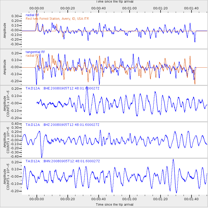
D12A Red Ives Forest Station, Avery, ID, USA - Earthquake Result Viewer
*The percent match for this event was below the threshold and hence no stack was calculated.
| Earthquake location: |
Vanuatu Islands |
| Earthquake latitude/longitude: |
-13.3/167.0 |
| Earthquake time(UTC): |
2008/09/05 (249) 12:35:43 GMT |
| Earthquake Depth: |
147 km |
| Earthquake Magnitude: |
5.6 MW, 5.3 MB, 5.6 MW |
| Earthquake Catalog/Contributor: |
WHDF/NEIC |
|
| Network: |
TA USArray Transportable Network (new EarthScope stations) |
| Station: |
D12A Red Ives Forest Station, Avery, ID, USA |
| Lat/Lon: |
47.05 N/115.35 W |
| Elevation: |
1135 m |
|
| Distance: |
91.4 deg |
| Az: |
41.931 deg |
| Baz: |
252.082 deg |
| Ray Param: |
$rayparam |
*The percent match for this event was below the threshold and hence was not used in the summary stack. |
|
| Radial Match: |
54.26777 % |
| Radial Bump: |
389 |
| Transverse Match: |
54.523777 % |
| Transverse Bump: |
394 |
| SOD ConfigId: |
2560 |
| Insert Time: |
2010-03-06 23:59:48.291 +0000 |
| GWidth: |
2.5 |
| Max Bumps: |
400 |
| Tol: |
0.001 |
|
Signal To Noise
| Channel | StoN | STA | LTA |
| TA:D12A: :BHZ:20080905T12:48:01.600027Z | 2.6199274 | 2.0082912E-7 | 7.665446E-8 |
| TA:D12A: :BHN:20080905T12:48:01.600027Z | 0.69706726 | 5.1869275E-8 | 7.4410714E-8 |
| TA:D12A: :BHE:20080905T12:48:01.600027Z | 4.0510693 | 1.14934096E-7 | 2.8371298E-8 |
| Arrivals |
| Ps | |
| PpPs | |
| PsPs/PpSs | |


