You are here: Home > Network List > TA - USArray Transportable Network (new EarthScope stations) Stations List
> Station D12A Red Ives Forest Station, Avery, ID, USA > Earthquake Result Viewer
D12A Red Ives Forest Station, Avery, ID, USA - Earthquake Result Viewer
*The percent match for this event was below the threshold and hence no stack was calculated.
| Earthquake location: |
Near Coast Of Northern Peru |
| Earthquake latitude/longitude: |
-5.9/-80.9 |
| Earthquake time(UTC): |
2009/02/15 (046) 10:04:49 GMT |
| Earthquake Depth: |
21 km |
| Earthquake Magnitude: |
5.8 MB, 5.7 MS, 6.1 MW, 6.1 MW |
| Earthquake Catalog/Contributor: |
WHDF/NEIC |
|
| Network: |
TA USArray Transportable Network (new EarthScope stations) |
| Station: |
D12A Red Ives Forest Station, Avery, ID, USA |
| Lat/Lon: |
47.05 N/115.35 W |
| Elevation: |
1135 m |
|
| Distance: |
60.9 deg |
| Az: |
333.706 deg |
| Baz: |
139.871 deg |
| Ray Param: |
$rayparam |
*The percent match for this event was below the threshold and hence was not used in the summary stack. |
|
| Radial Match: |
50.361023 % |
| Radial Bump: |
400 |
| Transverse Match: |
48.15642 % |
| Transverse Bump: |
391 |
| SOD ConfigId: |
2658 |
| Insert Time: |
2010-03-06 23:59:54.532 +0000 |
| GWidth: |
2.5 |
| Max Bumps: |
400 |
| Tol: |
0.001 |
|
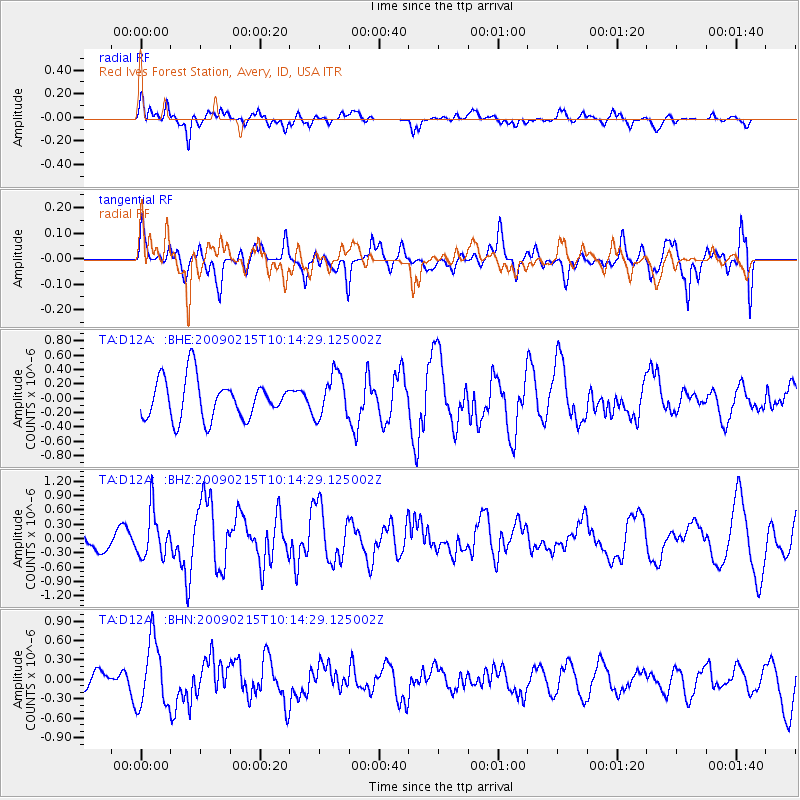
Signal To Noise
| Channel | StoN | STA | LTA |
| TA:D12A: :BHZ:20090215T10:14:29.125002Z | 2.0002296 | 4.7734557E-7 | 2.3864538E-7 |
| TA:D12A: :BHN:20090215T10:14:29.125002Z | 3.1637664 | 5.0835774E-7 | 1.6068118E-7 |
| TA:D12A: :BHE:20090215T10:14:29.125002Z | 1.0992614 | 3.0397732E-7 | 2.7652868E-7 |
| Arrivals |
| Ps | |
| PpPs | |
| PsPs/PpSs | |


