You are here: Home > Network List > GS - US Geological Survey Networks Stations List
> Station OK051 E0350 and S34600 Roads, Ralston, OK > Earthquake Result Viewer
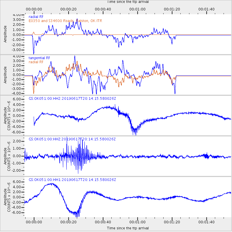
OK051 E0350 and S34600 Roads, Ralston, OK - Earthquake Result Viewer
*The percent match for this event was below the threshold and hence no stack was calculated.
| Earthquake location: |
Central Mid-Atlantic Ridge |
| Earthquake latitude/longitude: |
0.8/-26.2 |
| Earthquake time(UTC): |
2019/06/17 (168) 20:03:11 GMT |
| Earthquake Depth: |
10 km |
| Earthquake Magnitude: |
5.5 Mww |
| Earthquake Catalog/Contributor: |
NEIC PDE/us |
|
| Network: |
GS US Geological Survey Networks |
| Station: |
OK051 E0350 and S34600 Roads, Ralston, OK |
| Lat/Lon: |
36.51 N/96.84 W |
| Elevation: |
263 m |
|
| Distance: |
74.0 deg |
| Az: |
307.739 deg |
| Baz: |
101.064 deg |
| Ray Param: |
$rayparam |
*The percent match for this event was below the threshold and hence was not used in the summary stack. |
|
| Radial Match: |
40.47708 % |
| Radial Bump: |
276 |
| Transverse Match: |
30.057787 % |
| Transverse Bump: |
286 |
| SOD ConfigId: |
18369291 |
| Insert Time: |
2019-07-01 20:06:15.138 +0000 |
| GWidth: |
2.5 |
| Max Bumps: |
400 |
| Tol: |
0.001 |
|
Signal To Noise
| Channel | StoN | STA | LTA |
| GS:OK051:00:HHZ:20190617T20:14:15.580026Z | 0.7104649 | 1.3759988E-7 | 1.9367582E-7 |
| GS:OK051:00:HH1:20190617T20:14:15.580026Z | 1.7492207 | 3.3360543E-6 | 1.9071659E-6 |
| GS:OK051:00:HH2:20190617T20:14:15.580026Z | 1.0130409 | 8.485335E-7 | 8.3761023E-7 |
| Arrivals |
| Ps | |
| PpPs | |
| PsPs/PpSs | |


