You are here: Home > Network List > TA - USArray Transportable Network (new EarthScope stations) Stations List
> Station C12B Naegeli Ranch, Trout Creek, MT, USA > Earthquake Result Viewer
C12B Naegeli Ranch, Trout Creek, MT, USA - Earthquake Result Viewer
| Earthquake location: |
Andreanof Islands, Aleutian Is. |
| Earthquake latitude/longitude: |
52.2/-175.7 |
| Earthquake time(UTC): |
2008/08/07 (220) 18:30:03 GMT |
| Earthquake Depth: |
12 km |
| Earthquake Magnitude: |
5.6 MB, 5.5 MS, 5.8 MW, 5.8 MW |
| Earthquake Catalog/Contributor: |
WHDF/NEIC |
|
| Network: |
TA USArray Transportable Network (new EarthScope stations) |
| Station: |
C12B Naegeli Ranch, Trout Creek, MT, USA |
| Lat/Lon: |
47.71 N/115.47 W |
| Elevation: |
801 m |
|
| Distance: |
38.0 deg |
| Az: |
72.094 deg |
| Baz: |
299.845 deg |
| Ray Param: |
0.07580653 |
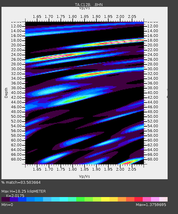
| Estimated Moho Depth: |
18.25 km |
| Estimated Crust Vp/Vs: |
2.02 |
| Assumed Crust Vp: |
6.622 km/s |
| Estimated Crust Vs: |
3.282 km/s |
| Estimated Crust Poisson's Ratio: |
0.34 |
|
| Radial Match: |
83.583664 % |
| Radial Bump: |
400 |
| Transverse Match: |
60.965137 % |
| Transverse Bump: |
400 |
| SOD ConfigId: |
2504 |
| Insert Time: |
2010-03-07 00:00:21.185 +0000 |
| GWidth: |
2.5 |
| Max Bumps: |
400 |
| Tol: |
0.001 |
|
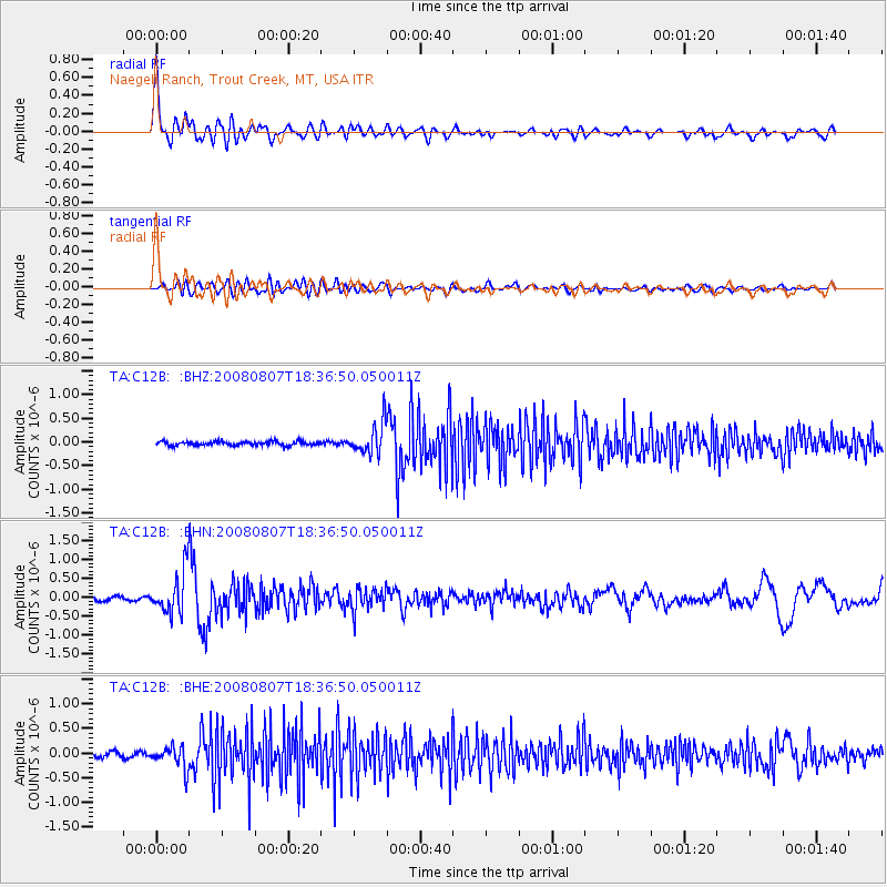
Signal To Noise
| Channel | StoN | STA | LTA |
| TA:C12B: :BHN:20080807T18:36:50.050011Z | 11.702107 | 5.5310215E-7 | 4.7265175E-8 |
| TA:C12B: :BHE:20080807T18:36:50.050011Z | 4.38848 | 2.2860502E-7 | 5.2092073E-8 |
| TA:C12B: :BHZ:20080807T18:36:50.050011Z | 7.644298 | 3.2370292E-7 | 4.234567E-8 |
| Arrivals |
| Ps | 3.0 SECOND |
| PpPs | 7.8 SECOND |
| PsPs/PpSs | 11 SECOND |


