You are here: Home > Network List > TA - USArray Transportable Network (new EarthScope stations) Stations List
> Station C12B Naegeli Ranch, Trout Creek, MT, USA > Earthquake Result Viewer
C12B Naegeli Ranch, Trout Creek, MT, USA - Earthquake Result Viewer
| Earthquake location: |
Kermadec Islands, New Zealand |
| Earthquake latitude/longitude: |
-29.8/-177.7 |
| Earthquake time(UTC): |
2008/09/29 (273) 15:19:31 GMT |
| Earthquake Depth: |
36 km |
| Earthquake Magnitude: |
6.5 MB, 6.7 MS, 7.0 MW, 7.0 MW |
| Earthquake Catalog/Contributor: |
WHDF/NEIC |
|
| Network: |
TA USArray Transportable Network (new EarthScope stations) |
| Station: |
C12B Naegeli Ranch, Trout Creek, MT, USA |
| Lat/Lon: |
47.71 N/115.47 W |
| Elevation: |
801 m |
|
| Distance: |
95.2 deg |
| Az: |
36.864 deg |
| Baz: |
230.572 deg |
| Ray Param: |
0.04083337 |
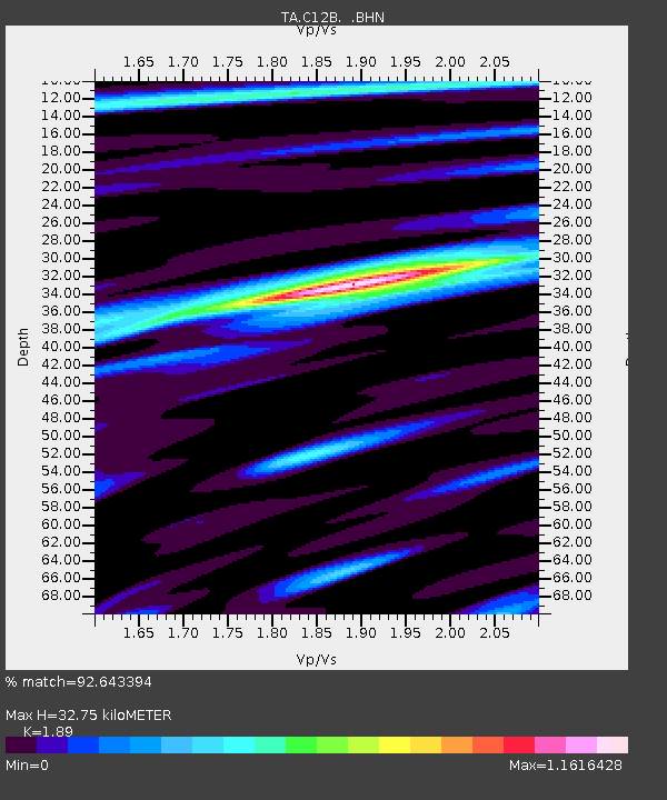
| Estimated Moho Depth: |
32.75 km |
| Estimated Crust Vp/Vs: |
1.89 |
| Assumed Crust Vp: |
6.622 km/s |
| Estimated Crust Vs: |
3.504 km/s |
| Estimated Crust Poisson's Ratio: |
0.31 |
|
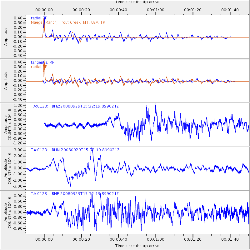
| Radial Match: |
92.643394 % |
| Radial Bump: |
400 |
| Transverse Match: |
72.72796 % |
| Transverse Bump: |
400 |
| SOD ConfigId: |
2560 |
| Insert Time: |
2010-03-07 00:00:36.353 +0000 |
| GWidth: |
2.5 |
| Max Bumps: |
400 |
| Tol: |
0.001 |
|
Signal To Noise
| Channel | StoN | STA | LTA |
| TA:C12B: :BHN:20080929T15:32:19.899021Z | 8.111404 | 6.869374E-7 | 8.468786E-8 |
| TA:C12B: :BHE:20080929T15:32:19.899021Z | 1.9018462 | 1.4666938E-7 | 7.711947E-8 |
| TA:C12B: :BHZ:20080929T15:32:19.899021Z | 1.9149084 | 1.6018342E-7 | 8.36507E-8 |
| Arrivals |
| Ps | 4.5 SECOND |
| PpPs | 14 SECOND |
| PsPs/PpSs | 19 SECOND |


