You are here: Home > Network List > TS - TERRAscope (Southern California Seismic Network) Stations List
> Station GSC Goldston, California, USA > Earthquake Result Viewer
GSC Goldston, California, USA - Earthquake Result Viewer
| Earthquake location: |
Fiji Islands Region |
| Earthquake latitude/longitude: |
-22.0/-179.6 |
| Earthquake time(UTC): |
1994/03/31 (090) 22:40:53 GMT |
| Earthquake Depth: |
591 km |
| Earthquake Magnitude: |
5.9 MB, 6.5 UNKNOWN, 6.5 MW |
| Earthquake Catalog/Contributor: |
WHDF/NEIC |
|
| Network: |
TS TERRAscope (Southern California Seismic Network) |
| Station: |
GSC Goldston, California, USA |
| Lat/Lon: |
35.30 N/116.81 W |
| Elevation: |
990 m |
|
| Distance: |
82.3 deg |
| Az: |
47.213 deg |
| Baz: |
236.405 deg |
| Ray Param: |
0.045192104 |
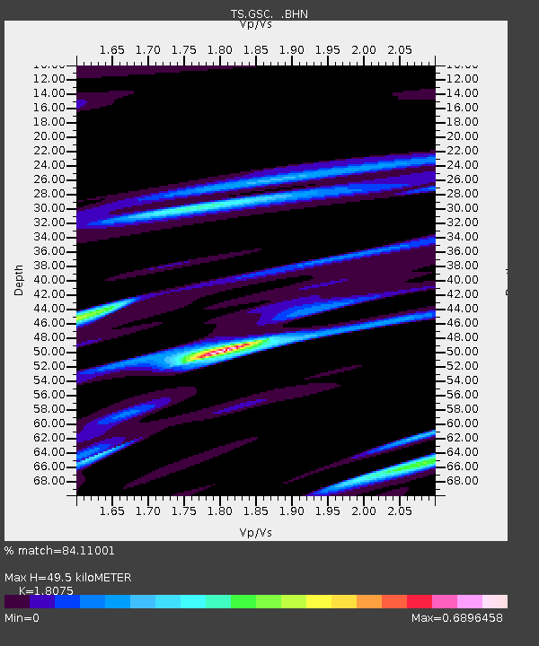
| Estimated Moho Depth: |
49.5 km |
| Estimated Crust Vp/Vs: |
1.81 |
| Assumed Crust Vp: |
6.276 km/s |
| Estimated Crust Vs: |
3.472 km/s |
| Estimated Crust Poisson's Ratio: |
0.28 |
|
| Radial Match: |
84.11001 % |
| Radial Bump: |
400 |
| Transverse Match: |
80.69257 % |
| Transverse Bump: |
400 |
| SOD ConfigId: |
16938 |
| Insert Time: |
2010-02-26 14:16:31.630 +0000 |
| GWidth: |
2.5 |
| Max Bumps: |
400 |
| Tol: |
0.001 |
|

Signal To Noise
| Channel | StoN | STA | LTA |
| TS:GSC: :BHN:19940331T22:51:42.946021Z | 2.1960742 | 4.236029E-7 | 1.9289098E-7 |
| TS:GSC: :BHE:19940331T22:51:42.946021Z | 2.5874953 | 5.22013E-7 | 2.0174453E-7 |
| TS:GSC: :BHZ:19940331T22:51:42.946021Z | 10.387767 | 2.2294257E-6 | 2.146203E-7 |
| Arrivals |
| Ps | 6.5 SECOND |
| PpPs | 22 SECOND |
| PsPs/PpSs | 28 SECOND |


