You are here: Home > Network List > IU - Global Seismograph Network (GSN - IRIS/USGS) Stations List
> Station KEV Kevo, Finland > Earthquake Result Viewer
KEV Kevo, Finland - Earthquake Result Viewer
| Earthquake location: |
Near East Coast Of Honshu, Japan |
| Earthquake latitude/longitude: |
37.4/141.4 |
| Earthquake time(UTC): |
2016/11/21 (326) 20:59:49 GMT |
| Earthquake Depth: |
11 km |
| Earthquake Magnitude: |
6.9 MWB, 7.3 MI |
| Earthquake Catalog/Contributor: |
NEIC PDE/NEIC COMCAT |
|
| Network: |
IU Global Seismograph Network (GSN - IRIS/USGS) |
| Station: |
KEV Kevo, Finland |
| Lat/Lon: |
69.76 N/27.00 E |
| Elevation: |
100 m |
|
| Distance: |
63.1 deg |
| Az: |
339.181 deg |
| Baz: |
54.42 deg |
| Ray Param: |
0.05978972 |
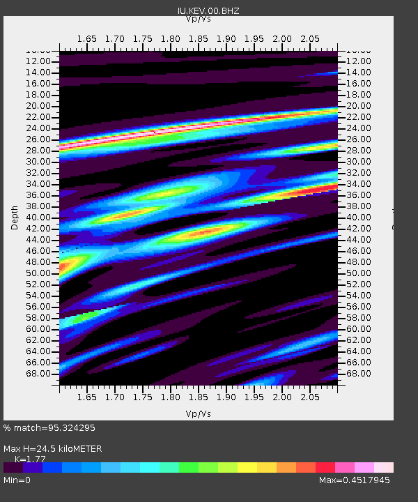
| Estimated Moho Depth: |
24.5 km |
| Estimated Crust Vp/Vs: |
1.77 |
| Assumed Crust Vp: |
6.622 km/s |
| Estimated Crust Vs: |
3.741 km/s |
| Estimated Crust Poisson's Ratio: |
0.27 |
|
| Radial Match: |
95.324295 % |
| Radial Bump: |
347 |
| Transverse Match: |
84.361084 % |
| Transverse Bump: |
400 |
| SOD ConfigId: |
1858631 |
| Insert Time: |
2016-12-05 21:02:46.581 +0000 |
| GWidth: |
2.5 |
| Max Bumps: |
400 |
| Tol: |
0.001 |
|

Signal To Noise
| Channel | StoN | STA | LTA |
| IU:KEV:00:BHZ:20161121T21:09:45.268972Z | 2.357499 | 1.0829023E-6 | 4.593437E-7 |
| IU:KEV:00:BH1:20161121T21:09:45.268972Z | 1.5404177 | 3.7753696E-7 | 2.450874E-7 |
| IU:KEV:00:BH2:20161121T21:09:45.268972Z | 2.5941222 | 5.4607443E-7 | 2.1050451E-7 |
| Arrivals |
| Ps | 3.0 SECOND |
| PpPs | 9.8 SECOND |
| PsPs/PpSs | 13 SECOND |


