You are here: Home > Network List > IU - Global Seismograph Network (GSN - IRIS/USGS) Stations List
> Station MAKZ Makanchi, Kazakhstan > Earthquake Result Viewer
MAKZ Makanchi, Kazakhstan - Earthquake Result Viewer
| Earthquake location: |
Near East Coast Of Honshu, Japan |
| Earthquake latitude/longitude: |
37.4/141.4 |
| Earthquake time(UTC): |
2016/11/21 (326) 20:59:49 GMT |
| Earthquake Depth: |
11 km |
| Earthquake Magnitude: |
6.9 MWB, 7.3 MI |
| Earthquake Catalog/Contributor: |
NEIC PDE/NEIC COMCAT |
|
| Network: |
IU Global Seismograph Network (GSN - IRIS/USGS) |
| Station: |
MAKZ Makanchi, Kazakhstan |
| Lat/Lon: |
46.81 N/81.98 E |
| Elevation: |
600 m |
|
| Distance: |
44.1 deg |
| Az: |
301.863 deg |
| Baz: |
80.0 deg |
| Ray Param: |
0.072101496 |
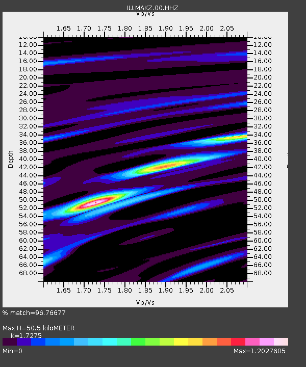
| Estimated Moho Depth: |
50.5 km |
| Estimated Crust Vp/Vs: |
1.73 |
| Assumed Crust Vp: |
6.571 km/s |
| Estimated Crust Vs: |
3.804 km/s |
| Estimated Crust Poisson's Ratio: |
0.25 |
|
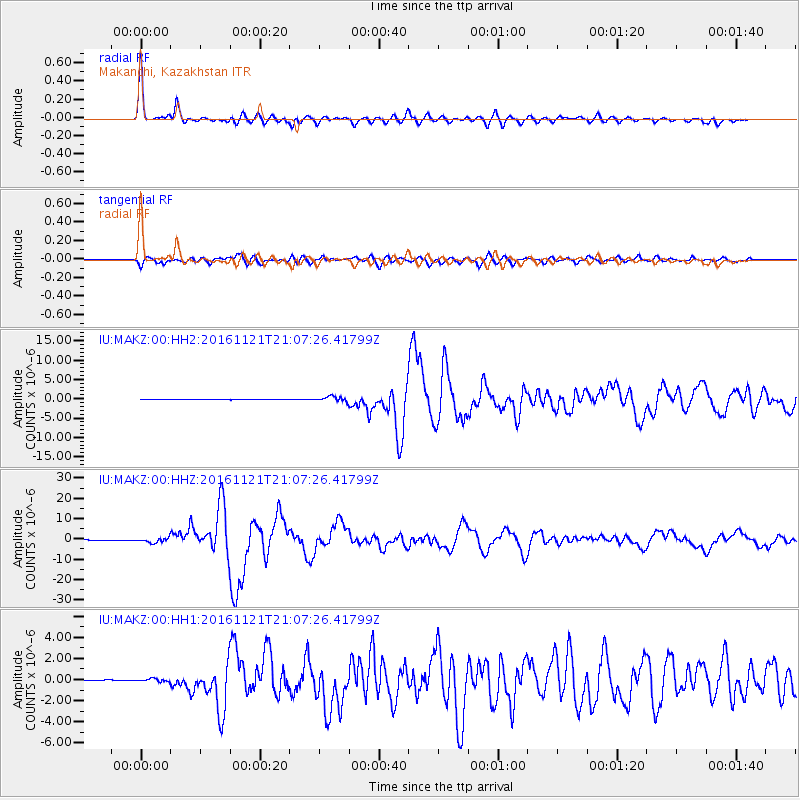
| Radial Match: |
96.76677 % |
| Radial Bump: |
400 |
| Transverse Match: |
88.3354 % |
| Transverse Bump: |
400 |
| SOD ConfigId: |
1858631 |
| Insert Time: |
2016-12-05 21:02:50.150 +0000 |
| GWidth: |
2.5 |
| Max Bumps: |
400 |
| Tol: |
0.001 |
|
Signal To Noise
| Channel | StoN | STA | LTA |
| IU:MAKZ:00:HHZ:20161121T21:07:26.41799Z | 12.838245 | 1.1658203E-6 | 9.080838E-8 |
| IU:MAKZ:00:HH1:20161121T21:07:26.41799Z | 1.6793436 | 1.9585312E-7 | 1.16624804E-7 |
| IU:MAKZ:00:HH2:20161121T21:07:26.41799Z | 13.827731 | 6.357216E-7 | 4.5974396E-8 |
| Arrivals |
| Ps | 6.0 SECOND |
| PpPs | 20 SECOND |
| PsPs/PpSs | 26 SECOND |


