You are here: Home > Network List > AE - Arizona Broadband Seismic Network Stations List
> Station TONTO Roosevelt/Tonto Basin > Earthquake Result Viewer
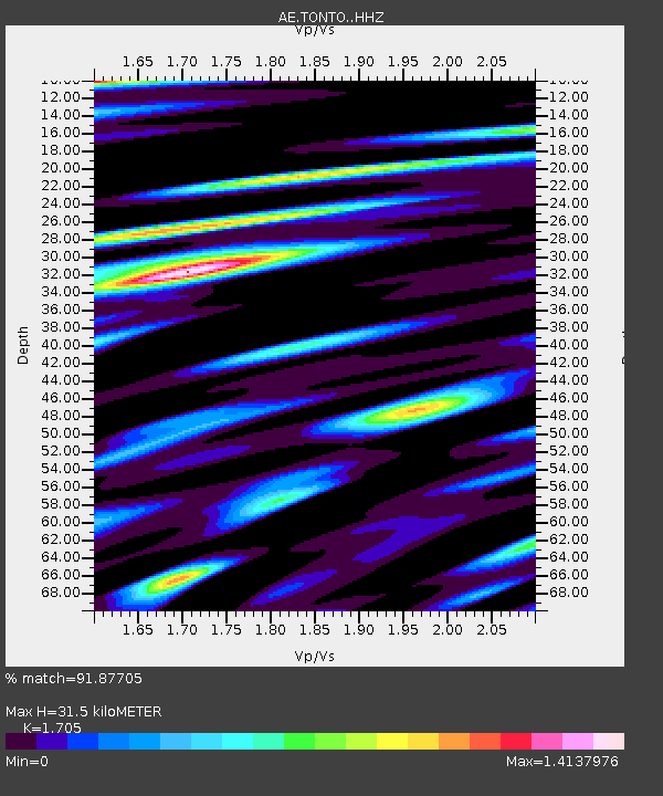
TONTO Roosevelt/Tonto Basin - Earthquake Result Viewer
| Earthquake location: |
Near West Coast Of Honshu, Japan |
| Earthquake latitude/longitude: |
38.6/139.5 |
| Earthquake time(UTC): |
2019/06/18 (169) 13:22:19 GMT |
| Earthquake Depth: |
12 km |
| Earthquake Magnitude: |
6.4 Mww |
| Earthquake Catalog/Contributor: |
NEIC PDE/us |
|
| Network: |
AE Arizona Broadband Seismic Network |
| Station: |
TONTO Roosevelt/Tonto Basin |
| Lat/Lon: |
33.65 N/111.01 W |
| Elevation: |
661 m |
|
| Distance: |
82.8 deg |
| Az: |
52.411 deg |
| Baz: |
311.938 deg |
| Ray Param: |
0.04660946 |
| Estimated Moho Depth: |
31.5 km |
| Estimated Crust Vp/Vs: |
1.71 |
| Assumed Crust Vp: |
6.276 km/s |
| Estimated Crust Vs: |
3.681 km/s |
| Estimated Crust Poisson's Ratio: |
0.24 |
|
| Radial Match: |
91.87705 % |
| Radial Bump: |
400 |
| Transverse Match: |
90.92722 % |
| Transverse Bump: |
400 |
| SOD ConfigId: |
18369291 |
| Insert Time: |
2019-07-02 13:22:37.995 +0000 |
| GWidth: |
2.5 |
| Max Bumps: |
400 |
| Tol: |
0.001 |
|

Signal To Noise
| Channel | StoN | STA | LTA |
| AE:TONTO: :HHZ:20190618T13:34:11.648986Z | 2.3238199 | 2.0024733E-7 | 8.6171625E-8 |
| AE:TONTO: :HHN:20190618T13:34:11.648986Z | 1.269566 | 1.3113316E-7 | 1.0328975E-7 |
| AE:TONTO: :HHE:20190618T13:34:11.648986Z | 0.76635003 | 8.697801E-8 | 1.1349646E-7 |
| Arrivals |
| Ps | 3.6 SECOND |
| PpPs | 13 SECOND |
| PsPs/PpSs | 17 SECOND |


