You are here: Home > Network List > AG - Arkansas Seismic Network Stations List
> Station HHAR Hobbs,AR > Earthquake Result Viewer
HHAR Hobbs,AR - Earthquake Result Viewer
| Earthquake location: |
Near West Coast Of Honshu, Japan |
| Earthquake latitude/longitude: |
38.6/139.5 |
| Earthquake time(UTC): |
2019/06/18 (169) 13:22:19 GMT |
| Earthquake Depth: |
12 km |
| Earthquake Magnitude: |
6.4 Mww |
| Earthquake Catalog/Contributor: |
NEIC PDE/us |
|
| Network: |
AG Arkansas Seismic Network |
| Station: |
HHAR Hobbs,AR |
| Lat/Lon: |
36.28 N/93.94 W |
| Elevation: |
421 m |
|
| Distance: |
90.6 deg |
| Az: |
40.453 deg |
| Baz: |
321.039 deg |
| Ray Param: |
0.041660585 |
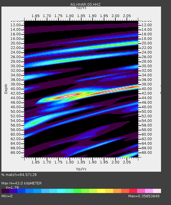
| Estimated Moho Depth: |
43.0 km |
| Estimated Crust Vp/Vs: |
1.79 |
| Assumed Crust Vp: |
6.53 km/s |
| Estimated Crust Vs: |
3.648 km/s |
| Estimated Crust Poisson's Ratio: |
0.27 |
|
| Radial Match: |
94.57129 % |
| Radial Bump: |
264 |
| Transverse Match: |
85.86135 % |
| Transverse Bump: |
357 |
| SOD ConfigId: |
18369291 |
| Insert Time: |
2019-07-02 13:22:41.652 +0000 |
| GWidth: |
2.5 |
| Max Bumps: |
400 |
| Tol: |
0.001 |
|

Signal To Noise
| Channel | StoN | STA | LTA |
| AG:HHAR:00:HHZ:20190618T13:34:49.530029Z | 13.2394705 | 8.863346E-7 | 6.694638E-8 |
| AG:HHAR:00:HHN:20190618T13:34:49.530029Z | 4.600742 | 2.259069E-7 | 4.910228E-8 |
| AG:HHAR:00:HHE:20190618T13:34:49.530029Z | 5.681471 | 2.2290402E-7 | 3.9233505E-8 |
| Arrivals |
| Ps | 5.3 SECOND |
| PpPs | 18 SECOND |
| PsPs/PpSs | 23 SECOND |


