You are here: Home > Network List > OK - Oklahoma Seismic Network Stations List
> Station FNO Franklin, Norman, OK > Earthquake Result Viewer
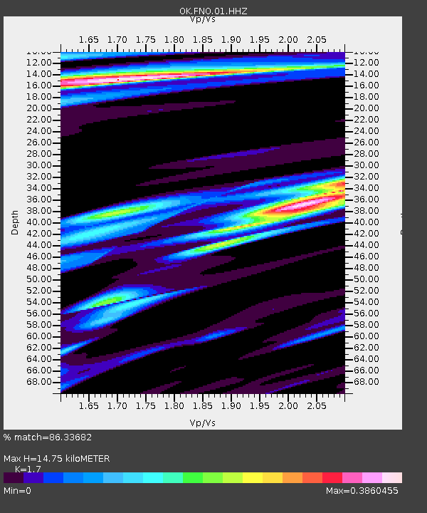
FNO Franklin, Norman, OK - Earthquake Result Viewer
| Earthquake location: |
Near East Coast Of Honshu, Japan |
| Earthquake latitude/longitude: |
37.4/141.4 |
| Earthquake time(UTC): |
2016/11/21 (326) 20:59:49 GMT |
| Earthquake Depth: |
11 km |
| Earthquake Magnitude: |
6.9 MWB, 7.3 MI |
| Earthquake Catalog/Contributor: |
NEIC PDE/NEIC COMCAT |
|
| Network: |
OK Oklahoma Seismic Network |
| Station: |
FNO Franklin, Norman, OK |
| Lat/Lon: |
35.26 N/97.40 W |
| Elevation: |
360 m |
|
| Distance: |
89.4 deg |
| Az: |
44.434 deg |
| Baz: |
317.053 deg |
| Ray Param: |
0.041850246 |
| Estimated Moho Depth: |
14.75 km |
| Estimated Crust Vp/Vs: |
1.70 |
| Assumed Crust Vp: |
6.426 km/s |
| Estimated Crust Vs: |
3.78 km/s |
| Estimated Crust Poisson's Ratio: |
0.24 |
|
| Radial Match: |
86.33682 % |
| Radial Bump: |
400 |
| Transverse Match: |
74.87959 % |
| Transverse Bump: |
399 |
| SOD ConfigId: |
1858631 |
| Insert Time: |
2016-12-05 21:04:32.303 +0000 |
| GWidth: |
2.5 |
| Max Bumps: |
400 |
| Tol: |
0.001 |
|

Signal To Noise
| Channel | StoN | STA | LTA |
| OK:FNO:01:HHZ:20161121T21:12:14.179006Z | 4.8055015 | 1.2677345E-6 | 2.6380903E-7 |
| OK:FNO:01:HHN:20161121T21:12:14.179006Z | 0.810453 | 4.559838E-7 | 5.626283E-7 |
| OK:FNO:01:HHE:20161121T21:12:14.179006Z | 2.4004257 | 7.809063E-7 | 3.2531995E-7 |
| Arrivals |
| Ps | 1.6 SECOND |
| PpPs | 6.1 SECOND |
| PsPs/PpSs | 7.7 SECOND |


