You are here: Home > Network List > CI - Caltech Regional Seismic Network Stations List
> Station BFS Mt Baldy Forest Station > Earthquake Result Viewer
BFS Mt Baldy Forest Station - Earthquake Result Viewer
| Earthquake location: |
Near West Coast Of Honshu, Japan |
| Earthquake latitude/longitude: |
38.6/139.5 |
| Earthquake time(UTC): |
2019/06/18 (169) 13:22:19 GMT |
| Earthquake Depth: |
12 km |
| Earthquake Magnitude: |
6.4 Mww |
| Earthquake Catalog/Contributor: |
NEIC PDE/us |
|
| Network: |
CI Caltech Regional Seismic Network |
| Station: |
BFS Mt Baldy Forest Station |
| Lat/Lon: |
34.24 N/117.66 W |
| Elevation: |
1312 m |
|
| Distance: |
78.2 deg |
| Az: |
55.585 deg |
| Baz: |
308.761 deg |
| Ray Param: |
0.049773782 |
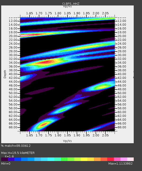
| Estimated Moho Depth: |
19.5 km |
| Estimated Crust Vp/Vs: |
1.60 |
| Assumed Crust Vp: |
6.276 km/s |
| Estimated Crust Vs: |
3.922 km/s |
| Estimated Crust Poisson's Ratio: |
0.18 |
|
| Radial Match: |
89.00612 % |
| Radial Bump: |
400 |
| Transverse Match: |
78.21866 % |
| Transverse Bump: |
400 |
| SOD ConfigId: |
18369291 |
| Insert Time: |
2019-07-02 13:25:11.952 +0000 |
| GWidth: |
2.5 |
| Max Bumps: |
400 |
| Tol: |
0.001 |
|

Signal To Noise
| Channel | StoN | STA | LTA |
| CI:BFS: :HHZ:20190618T13:33:47.098022Z | 4.4572425 | 5.9116906E-7 | 1.3263111E-7 |
| CI:BFS: :HHN:20190618T13:33:47.098022Z | 0.62912285 | 7.893615E-8 | 1.2547015E-7 |
| CI:BFS: :HHE:20190618T13:33:47.098022Z | 2.3162098 | 1.6326982E-7 | 7.049008E-8 |
| Arrivals |
| Ps | 1.9 SECOND |
| PpPs | 7.8 SECOND |
| PsPs/PpSs | 9.8 SECOND |


