You are here: Home > Network List > TA - USArray Transportable Network (new EarthScope stations) Stations List
> Station C12B Naegeli Ranch, Trout Creek, MT, USA > Earthquake Result Viewer
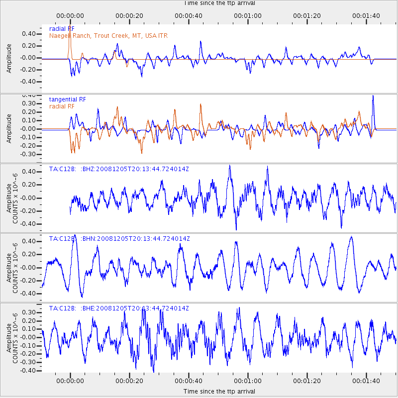
C12B Naegeli Ranch, Trout Creek, MT, USA - Earthquake Result Viewer
*The percent match for this event was below the threshold and hence no stack was calculated.
| Earthquake location: |
Off East Coast Of Honshu, Japan |
| Earthquake latitude/longitude: |
38.5/143.0 |
| Earthquake time(UTC): |
2008/12/05 (340) 20:03:11 GMT |
| Earthquake Depth: |
34 km |
| Earthquake Magnitude: |
5.5 MW, 5.2 MS, 5.2 MB, 5.5 MW |
| Earthquake Catalog/Contributor: |
WHDF/NEIC |
|
| Network: |
TA USArray Transportable Network (new EarthScope stations) |
| Station: |
C12B Naegeli Ranch, Trout Creek, MT, USA |
| Lat/Lon: |
47.71 N/115.47 W |
| Elevation: |
801 m |
|
| Distance: |
69.4 deg |
| Az: |
44.984 deg |
| Baz: |
304.818 deg |
| Ray Param: |
$rayparam |
*The percent match for this event was below the threshold and hence was not used in the summary stack. |
|
| Radial Match: |
61.498833 % |
| Radial Bump: |
400 |
| Transverse Match: |
39.31311 % |
| Transverse Bump: |
400 |
| SOD ConfigId: |
2658 |
| Insert Time: |
2010-03-07 00:03:28.744 +0000 |
| GWidth: |
2.5 |
| Max Bumps: |
400 |
| Tol: |
0.001 |
|
Signal To Noise
| Channel | StoN | STA | LTA |
| TA:C12B: :BHN:20081205T20:13:44.724014Z | 2.440997 | 3.2519466E-7 | 1.3322207E-7 |
| TA:C12B: :BHE:20081205T20:13:44.724014Z | 1.0976266 | 1.1680334E-7 | 1.0641447E-7 |
| TA:C12B: :BHZ:20081205T20:13:44.724014Z | 1.543245 | 1.5136364E-7 | 9.808141E-8 |
| Arrivals |
| Ps | |
| PpPs | |
| PsPs/PpSs | |


