You are here: Home > Network List > CN - Canadian National Seismograph Network Stations List
> Station POIN Pond Inlet, NU, CA > Earthquake Result Viewer
POIN Pond Inlet, NU, CA - Earthquake Result Viewer
| Earthquake location: |
Near West Coast Of Honshu, Japan |
| Earthquake latitude/longitude: |
38.6/139.5 |
| Earthquake time(UTC): |
2019/06/18 (169) 13:22:19 GMT |
| Earthquake Depth: |
12 km |
| Earthquake Magnitude: |
6.4 Mww |
| Earthquake Catalog/Contributor: |
NEIC PDE/us |
|
| Network: |
CN Canadian National Seismograph Network |
| Station: |
POIN Pond Inlet, NU, CA |
| Lat/Lon: |
72.70 N/77.96 W |
| Elevation: |
21 m |
|
| Distance: |
66.0 deg |
| Az: |
11.486 deg |
| Baz: |
328.587 deg |
| Ray Param: |
0.057927266 |
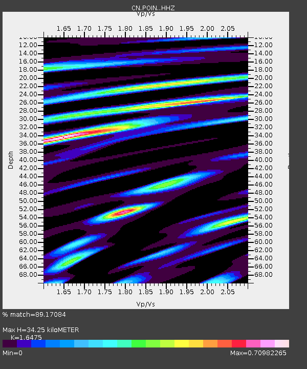
| Estimated Moho Depth: |
34.25 km |
| Estimated Crust Vp/Vs: |
1.65 |
| Assumed Crust Vp: |
6.367 km/s |
| Estimated Crust Vs: |
3.864 km/s |
| Estimated Crust Poisson's Ratio: |
0.21 |
|
| Radial Match: |
89.17084 % |
| Radial Bump: |
400 |
| Transverse Match: |
75.14807 % |
| Transverse Bump: |
400 |
| SOD ConfigId: |
18369291 |
| Insert Time: |
2019-07-02 13:26:40.123 +0000 |
| GWidth: |
2.5 |
| Max Bumps: |
400 |
| Tol: |
0.001 |
|

Signal To Noise
| Channel | StoN | STA | LTA |
| CN:POIN: :HHZ:20190618T13:32:33.760009Z | 44.034393 | 2.1479946E-6 | 4.877993E-8 |
| CN:POIN: :HHN:20190618T13:32:33.760009Z | 11.287458 | 6.609131E-7 | 5.855287E-8 |
| CN:POIN: :HHE:20190618T13:32:33.760009Z | 19.796112 | 7.824436E-7 | 3.9525112E-8 |
| Arrivals |
| Ps | 3.6 SECOND |
| PpPs | 14 SECOND |
| PsPs/PpSs | 17 SECOND |


