You are here: Home > Network List > GB - Great Britain Seismograph Network Stations List
> Station FOEL TREGEIROG, WALES > Earthquake Result Viewer
FOEL TREGEIROG, WALES - Earthquake Result Viewer
| Earthquake location: |
Near West Coast Of Honshu, Japan |
| Earthquake latitude/longitude: |
38.6/139.5 |
| Earthquake time(UTC): |
2019/06/18 (169) 13:22:19 GMT |
| Earthquake Depth: |
12 km |
| Earthquake Magnitude: |
6.4 Mww |
| Earthquake Catalog/Contributor: |
NEIC PDE/us |
|
| Network: |
GB Great Britain Seismograph Network |
| Station: |
FOEL TREGEIROG, WALES |
| Lat/Lon: |
52.89 N/3.20 W |
| Elevation: |
449 m |
|
| Distance: |
83.3 deg |
| Az: |
338.285 deg |
| Baz: |
28.563 deg |
| Ray Param: |
0.046314903 |
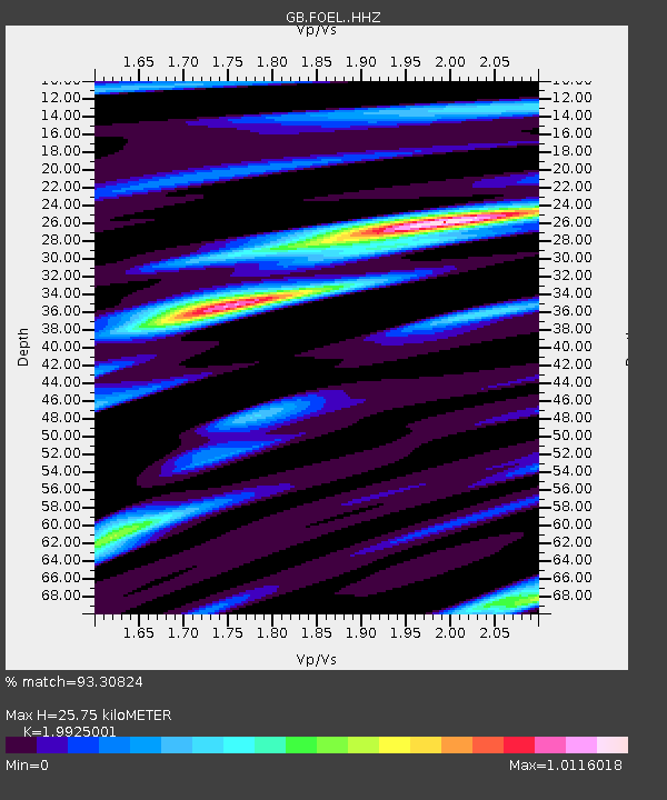
| Estimated Moho Depth: |
25.75 km |
| Estimated Crust Vp/Vs: |
1.99 |
| Assumed Crust Vp: |
6.276 km/s |
| Estimated Crust Vs: |
3.15 km/s |
| Estimated Crust Poisson's Ratio: |
0.33 |
|
| Radial Match: |
93.30824 % |
| Radial Bump: |
400 |
| Transverse Match: |
73.27788 % |
| Transverse Bump: |
400 |
| SOD ConfigId: |
18369291 |
| Insert Time: |
2019-07-02 13:27:24.536 +0000 |
| GWidth: |
2.5 |
| Max Bumps: |
400 |
| Tol: |
0.001 |
|

Signal To Noise
| Channel | StoN | STA | LTA |
| GB:FOEL: :HHZ:20190618T13:34:13.830017Z | 11.893685 | 5.9807246E-7 | 5.0284875E-8 |
| GB:FOEL: :HHN:20190618T13:34:13.830017Z | 3.3466105 | 2.1295686E-7 | 6.363359E-8 |
| GB:FOEL: :HHE:20190618T13:34:13.830017Z | 2.3068035 | 9.9117614E-8 | 4.2967514E-8 |
| Arrivals |
| Ps | 4.2 SECOND |
| PpPs | 12 SECOND |
| PsPs/PpSs | 16 SECOND |


