You are here: Home > Network List > TA - USArray Transportable Network (new EarthScope stations) Stations List
> Station C12B Naegeli Ranch, Trout Creek, MT, USA > Earthquake Result Viewer
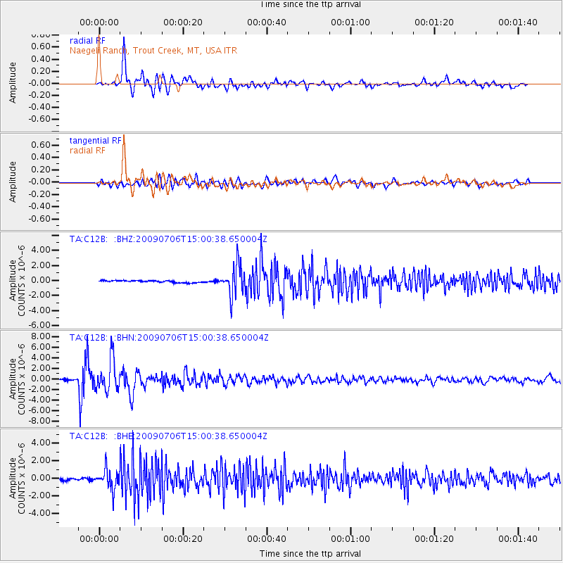
C12B Naegeli Ranch, Trout Creek, MT, USA - Earthquake Result Viewer
*The percent match for this event was below the threshold and hence no stack was calculated.
| Earthquake location: |
Rat Islands, Aleutian Islands |
| Earthquake latitude/longitude: |
50.4/177.0 |
| Earthquake time(UTC): |
2009/07/06 (187) 14:53:12 GMT |
| Earthquake Depth: |
22 km |
| Earthquake Magnitude: |
6.0 MB, 5.8 MS, 6.1 MW, 6.0 MW |
| Earthquake Catalog/Contributor: |
WHDF/NEIC |
|
| Network: |
TA USArray Transportable Network (new EarthScope stations) |
| Station: |
C12B Naegeli Ranch, Trout Creek, MT, USA |
| Lat/Lon: |
47.71 N/115.47 W |
| Elevation: |
801 m |
|
| Distance: |
42.9 deg |
| Az: |
66.359 deg |
| Baz: |
299.84 deg |
| Ray Param: |
$rayparam |
*The percent match for this event was below the threshold and hence was not used in the summary stack. |
|
| Radial Match: |
91.968056 % |
| Radial Bump: |
400 |
| Transverse Match: |
77.17975 % |
| Transverse Bump: |
400 |
| SOD ConfigId: |
2648 |
| Insert Time: |
2010-03-07 00:03:49.828 +0000 |
| GWidth: |
2.5 |
| Max Bumps: |
400 |
| Tol: |
0.001 |
|
Signal To Noise
| Channel | StoN | STA | LTA |
| TA:C12B: :BHN:20090706T15:00:38.650004Z | 29.102297 | 3.0482283E-6 | 1.0474185E-7 |
| TA:C12B: :BHE:20090706T15:00:38.650004Z | 9.840106 | 1.1372366E-6 | 1.15571574E-7 |
| TA:C12B: :BHZ:20090706T15:00:38.650004Z | 15.954998 | 2.0451212E-6 | 1.281806E-7 |
| Arrivals |
| Ps | |
| PpPs | |
| PsPs/PpSs | |


