You are here: Home > Network List > TA - USArray Transportable Network (new EarthScope stations) Stations List
> Station C12B Naegeli Ranch, Trout Creek, MT, USA > Earthquake Result Viewer
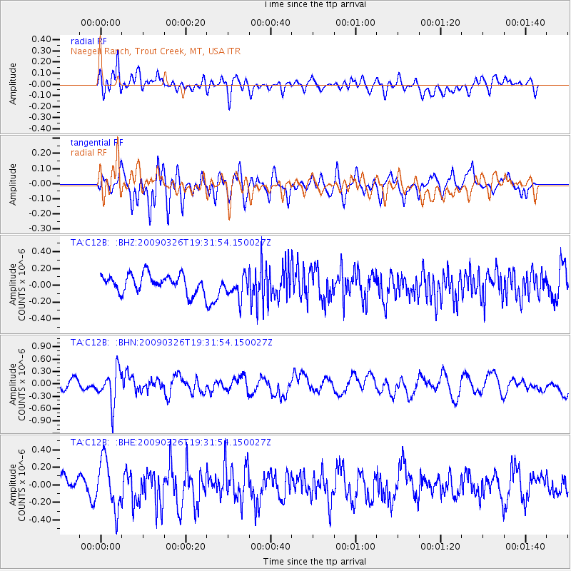
C12B Naegeli Ranch, Trout Creek, MT, USA - Earthquake Result Viewer
*The percent match for this event was below the threshold and hence no stack was calculated.
| Earthquake location: |
Northwest Of Ryukyu Islands |
| Earthquake latitude/longitude: |
27.4/126.7 |
| Earthquake time(UTC): |
2009/03/26 (085) 19:19:59 GMT |
| Earthquake Depth: |
160 km |
| Earthquake Magnitude: |
5.6 MB, 5.9 MW, 5.9 MW |
| Earthquake Catalog/Contributor: |
WHDF/NEIC |
|
| Network: |
TA USArray Transportable Network (new EarthScope stations) |
| Station: |
C12B Naegeli Ranch, Trout Creek, MT, USA |
| Lat/Lon: |
47.71 N/115.47 W |
| Elevation: |
801 m |
|
| Distance: |
86.7 deg |
| Az: |
36.747 deg |
| Baz: |
308.048 deg |
| Ray Param: |
$rayparam |
*The percent match for this event was below the threshold and hence was not used in the summary stack. |
|
| Radial Match: |
46.188145 % |
| Radial Bump: |
400 |
| Transverse Match: |
53.4593 % |
| Transverse Bump: |
400 |
| SOD ConfigId: |
2658 |
| Insert Time: |
2010-03-07 00:03:53.725 +0000 |
| GWidth: |
2.5 |
| Max Bumps: |
400 |
| Tol: |
0.001 |
|
Signal To Noise
| Channel | StoN | STA | LTA |
| TA:C12B: :BHN:20090326T19:31:54.150027Z | 2.542088 | 4.1701236E-7 | 1.6404323E-7 |
| TA:C12B: :BHE:20090326T19:31:54.150027Z | 3.267574 | 2.8211298E-7 | 8.633713E-8 |
| TA:C12B: :BHZ:20090326T19:31:54.150027Z | 1.3372982 | 1.4125831E-7 | 1.0562963E-7 |
| Arrivals |
| Ps | |
| PpPs | |
| PsPs/PpSs | |


