You are here: Home > Network List > GS - US Geological Survey Networks Stations List
> Station OK052 Battle Ridge Rd, NW of Cushing, OK, USA > Earthquake Result Viewer
OK052 Battle Ridge Rd, NW of Cushing, OK, USA - Earthquake Result Viewer
| Earthquake location: |
Near West Coast Of Honshu, Japan |
| Earthquake latitude/longitude: |
38.6/139.5 |
| Earthquake time(UTC): |
2019/06/18 (169) 13:22:19 GMT |
| Earthquake Depth: |
12 km |
| Earthquake Magnitude: |
6.4 Mww |
| Earthquake Catalog/Contributor: |
NEIC PDE/us |
|
| Network: |
GS US Geological Survey Networks |
| Station: |
OK052 Battle Ridge Rd, NW of Cushing, OK, USA |
| Lat/Lon: |
35.99 N/96.80 W |
| Elevation: |
259 m |
|
| Distance: |
89.4 deg |
| Az: |
42.417 deg |
| Baz: |
319.359 deg |
| Ray Param: |
0.041910667 |
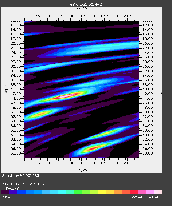
| Estimated Moho Depth: |
42.75 km |
| Estimated Crust Vp/Vs: |
1.78 |
| Assumed Crust Vp: |
6.426 km/s |
| Estimated Crust Vs: |
3.61 km/s |
| Estimated Crust Poisson's Ratio: |
0.27 |
|
| Radial Match: |
94.901085 % |
| Radial Bump: |
400 |
| Transverse Match: |
82.31165 % |
| Transverse Bump: |
400 |
| SOD ConfigId: |
18369291 |
| Insert Time: |
2019-07-02 13:27:57.091 +0000 |
| GWidth: |
2.5 |
| Max Bumps: |
400 |
| Tol: |
0.001 |
|

Signal To Noise
| Channel | StoN | STA | LTA |
| GS:OK052:00:HHZ:20190618T13:34:43.684021Z | 8.184083 | 7.524254E-7 | 9.193766E-8 |
| GS:OK052:00:HH1:20190618T13:34:43.684021Z | 1.3928151 | 1.618758E-7 | 1.1622204E-7 |
| GS:OK052:00:HH2:20190618T13:34:43.684021Z | 1.4601667 | 1.9957224E-7 | 1.3667771E-7 |
| Arrivals |
| Ps | 5.3 SECOND |
| PpPs | 18 SECOND |
| PsPs/PpSs | 23 SECOND |


