You are here: Home > Network List > TA - USArray Transportable Network (new EarthScope stations) Stations List
> Station C12B Naegeli Ranch, Trout Creek, MT, USA > Earthquake Result Viewer
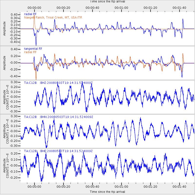
C12B Naegeli Ranch, Trout Creek, MT, USA - Earthquake Result Viewer
*The percent match for this event was below the threshold and hence no stack was calculated.
| Earthquake location: |
Solomon Islands |
| Earthquake latitude/longitude: |
-6.6/155.1 |
| Earthquake time(UTC): |
2008/05/03 (124) 19:01:46 GMT |
| Earthquake Depth: |
35 km |
| Earthquake Magnitude: |
5.8 MW, 5.4 MS, 5.4 MB, 5.7 MW |
| Earthquake Catalog/Contributor: |
WHDF/NEIC |
|
| Network: |
TA USArray Transportable Network (new EarthScope stations) |
| Station: |
C12B Naegeli Ranch, Trout Creek, MT, USA |
| Lat/Lon: |
47.71 N/115.47 W |
| Elevation: |
801 m |
|
| Distance: |
94.5 deg |
| Az: |
42.641 deg |
| Baz: |
265.12 deg |
| Ray Param: |
$rayparam |
*The percent match for this event was below the threshold and hence was not used in the summary stack. |
|
| Radial Match: |
56.627045 % |
| Radial Bump: |
400 |
| Transverse Match: |
55.472485 % |
| Transverse Bump: |
400 |
| SOD ConfigId: |
2504 |
| Insert Time: |
2010-03-07 00:04:20.886 +0000 |
| GWidth: |
2.5 |
| Max Bumps: |
400 |
| Tol: |
0.001 |
|
Signal To Noise
| Channel | StoN | STA | LTA |
| TA:C12B: :BHN:20080503T19:14:31.524009Z | 0.5775837 | 5.3582035E-8 | 9.2769305E-8 |
| TA:C12B: :BHE:20080503T19:14:31.524009Z | 1.0791235 | 1.3490244E-7 | 1.2501113E-7 |
| TA:C12B: :BHZ:20080503T19:14:31.524009Z | 1.2630343 | 1.5961423E-7 | 1.2637364E-7 |
| Arrivals |
| Ps | |
| PpPs | |
| PsPs/PpSs | |


