You are here: Home > Network List > TA - USArray Transportable Network (new EarthScope stations) Stations List
> Station C12B Naegeli Ranch, Trout Creek, MT, USA > Earthquake Result Viewer
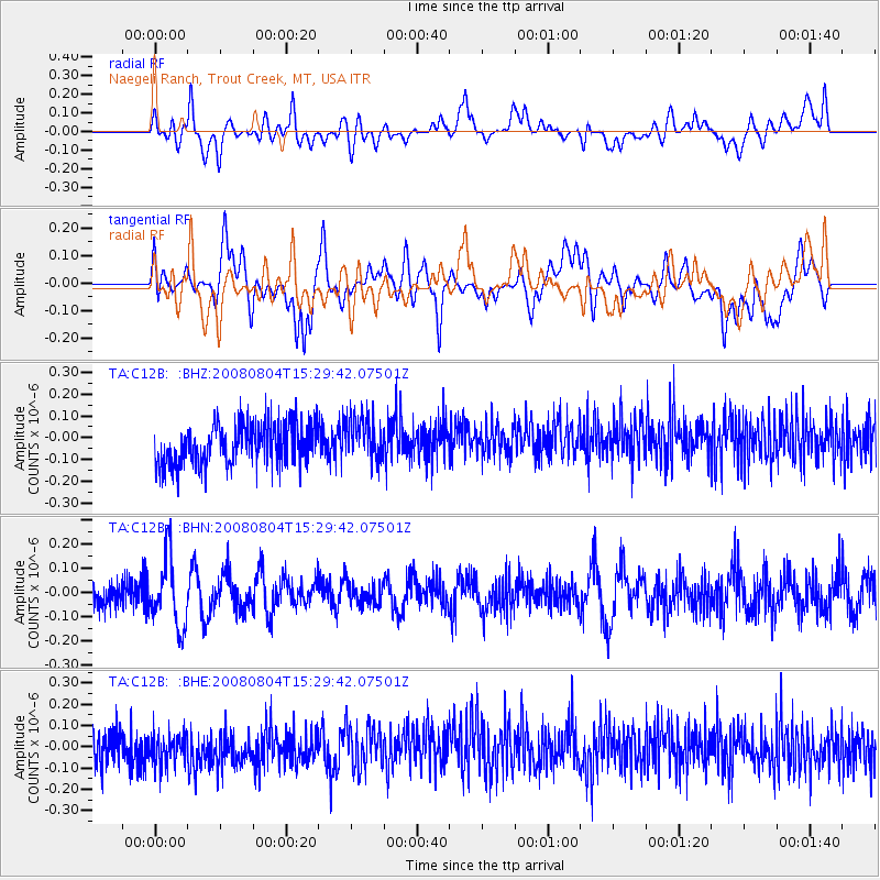
C12B Naegeli Ranch, Trout Creek, MT, USA - Earthquake Result Viewer
*The percent match for this event was below the threshold and hence no stack was calculated.
| Earthquake location: |
New Britain Region, P.N.G. |
| Earthquake latitude/longitude: |
-5.1/151.8 |
| Earthquake time(UTC): |
2008/08/04 (217) 15:16:53 GMT |
| Earthquake Depth: |
45 km |
| Earthquake Magnitude: |
5.5 MW, 4.8 MS, 5.2 MB |
| Earthquake Catalog/Contributor: |
WHDF/NEIC |
|
| Network: |
TA USArray Transportable Network (new EarthScope stations) |
| Station: |
C12B Naegeli Ranch, Trout Creek, MT, USA |
| Lat/Lon: |
47.71 N/115.47 W |
| Elevation: |
801 m |
|
| Distance: |
95.5 deg |
| Az: |
42.67 deg |
| Baz: |
268.607 deg |
| Ray Param: |
$rayparam |
*The percent match for this event was below the threshold and hence was not used in the summary stack. |
|
| Radial Match: |
44.29636 % |
| Radial Bump: |
400 |
| Transverse Match: |
41.816135 % |
| Transverse Bump: |
400 |
| SOD ConfigId: |
2504 |
| Insert Time: |
2010-03-07 00:04:31.570 +0000 |
| GWidth: |
2.5 |
| Max Bumps: |
400 |
| Tol: |
0.001 |
|
Signal To Noise
| Channel | StoN | STA | LTA |
| TA:C12B: :BHN:20080804T15:29:42.07501Z | 2.640042 | 1.4188677E-7 | 5.3744138E-8 |
| TA:C12B: :BHE:20080804T15:29:42.07501Z | 1.1619194 | 8.860233E-8 | 7.625515E-8 |
| TA:C12B: :BHZ:20080804T15:29:42.07501Z | 1.0636793 | 1.0089701E-7 | 9.48566E-8 |
| Arrivals |
| Ps | |
| PpPs | |
| PsPs/PpSs | |


