You are here: Home > Network List > TA - USArray Transportable Network (new EarthScope stations) Stations List
> Station C12B Naegeli Ranch, Trout Creek, MT, USA > Earthquake Result Viewer
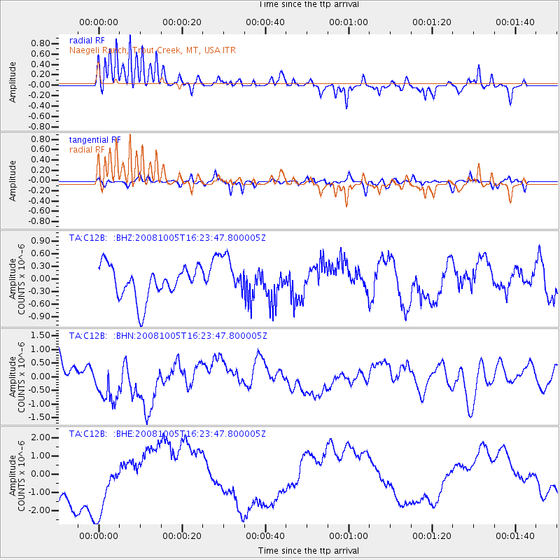
C12B Naegeli Ranch, Trout Creek, MT, USA - Earthquake Result Viewer
*The percent match for this event was below the threshold and hence no stack was calculated.
| Earthquake location: |
Tajikistan-Xinjiang Border Reg. |
| Earthquake latitude/longitude: |
39.5/73.9 |
| Earthquake time(UTC): |
2008/10/05 (279) 16:11:10 GMT |
| Earthquake Depth: |
35 km |
| Earthquake Magnitude: |
5.6 MB |
| Earthquake Catalog/Contributor: |
WHDF/NEIC |
|
| Network: |
TA USArray Transportable Network (new EarthScope stations) |
| Station: |
C12B Naegeli Ranch, Trout Creek, MT, USA |
| Lat/Lon: |
47.71 N/115.47 W |
| Elevation: |
801 m |
|
| Distance: |
92.8 deg |
| Az: |
6.315 deg |
| Baz: |
352.761 deg |
| Ray Param: |
$rayparam |
*The percent match for this event was below the threshold and hence was not used in the summary stack. |
|
| Radial Match: |
76.515915 % |
| Radial Bump: |
322 |
| Transverse Match: |
59.8344 % |
| Transverse Bump: |
341 |
| SOD ConfigId: |
2556 |
| Insert Time: |
2010-03-07 00:04:39.530 +0000 |
| GWidth: |
2.5 |
| Max Bumps: |
400 |
| Tol: |
0.001 |
|
Signal To Noise
| Channel | StoN | STA | LTA |
| TA:C12B: :BHN:20081005T16:23:47.800005Z | 1.7553533 | 8.6649493E-7 | 4.936299E-7 |
| TA:C12B: :BHE:20081005T16:23:47.800005Z | 1.2377621 | 1.7556232E-6 | 1.4183851E-6 |
| TA:C12B: :BHZ:20081005T16:23:47.800005Z | 1.2215482 | 4.6582807E-7 | 3.8134237E-7 |
| Arrivals |
| Ps | |
| PpPs | |
| PsPs/PpSs | |


