You are here: Home > Network List > N4 - Central and EAstern US Network Stations List
> Station T42B T42B > Earthquake Result Viewer
T42B T42B - Earthquake Result Viewer
| Earthquake location: |
Near West Coast Of Honshu, Japan |
| Earthquake latitude/longitude: |
38.6/139.5 |
| Earthquake time(UTC): |
2019/06/18 (169) 13:22:19 GMT |
| Earthquake Depth: |
12 km |
| Earthquake Magnitude: |
6.4 Mww |
| Earthquake Catalog/Contributor: |
NEIC PDE/us |
|
| Network: |
N4 Central and EAstern US Network |
| Station: |
T42B T42B |
| Lat/Lon: |
37.03 N/91.09 W |
| Elevation: |
165 m |
|
| Distance: |
91.4 deg |
| Az: |
38.19 deg |
| Baz: |
322.772 deg |
| Ray Param: |
0.041601717 |
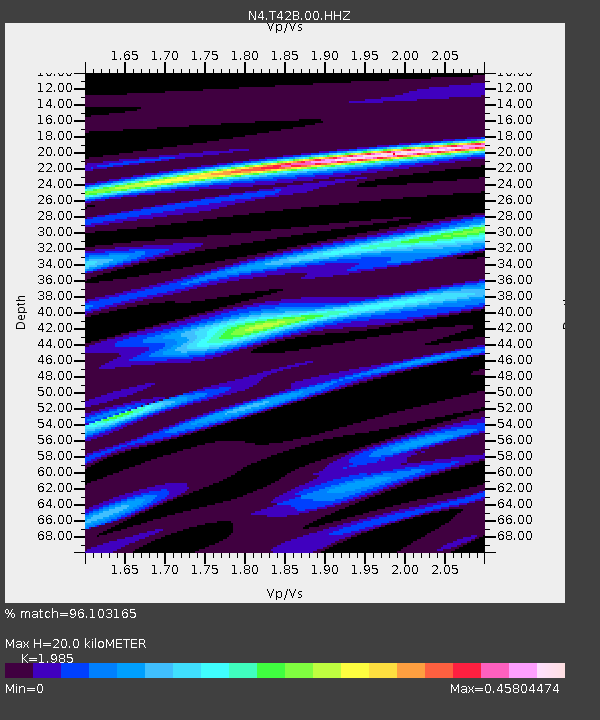
| Estimated Moho Depth: |
20.0 km |
| Estimated Crust Vp/Vs: |
1.99 |
| Assumed Crust Vp: |
6.53 km/s |
| Estimated Crust Vs: |
3.29 km/s |
| Estimated Crust Poisson's Ratio: |
0.33 |
|
| Radial Match: |
96.103165 % |
| Radial Bump: |
253 |
| Transverse Match: |
91.59116 % |
| Transverse Bump: |
400 |
| SOD ConfigId: |
18369291 |
| Insert Time: |
2019-07-02 13:29:58.997 +0000 |
| GWidth: |
2.5 |
| Max Bumps: |
400 |
| Tol: |
0.001 |
|

Signal To Noise
| Channel | StoN | STA | LTA |
| N4:T42B:00:HHZ:20190618T13:34:53.349975Z | 13.576856 | 7.1931476E-7 | 5.298095E-8 |
| N4:T42B:00:HH1:20190618T13:34:53.349975Z | 5.195506 | 2.1671707E-7 | 4.1712408E-8 |
| N4:T42B:00:HH2:20190618T13:34:53.349975Z | 4.758886 | 1.601749E-7 | 3.365807E-8 |
| Arrivals |
| Ps | 3.1 SECOND |
| PpPs | 9.0 SECOND |
| PsPs/PpSs | 12 SECOND |


