You are here: Home > Network List > TS - TERRAscope (Southern California Seismic Network) Stations List
> Station GSC Goldston, California, USA > Earthquake Result Viewer
GSC Goldston, California, USA - Earthquake Result Viewer
| Earthquake location: |
Santa Cruz Islands |
| Earthquake latitude/longitude: |
-11.5/166.4 |
| Earthquake time(UTC): |
1994/08/22 (234) 17:26:38 GMT |
| Earthquake Depth: |
148 km |
| Earthquake Magnitude: |
6.1 MB, 6.4 UNKNOWN, 6.1 MW |
| Earthquake Catalog/Contributor: |
WHDF/NEIC |
|
| Network: |
TS TERRAscope (Southern California Seismic Network) |
| Station: |
GSC Goldston, California, USA |
| Lat/Lon: |
35.30 N/116.81 W |
| Elevation: |
990 m |
|
| Distance: |
86.0 deg |
| Az: |
52.956 deg |
| Baz: |
253.04 deg |
| Ray Param: |
0.044024006 |
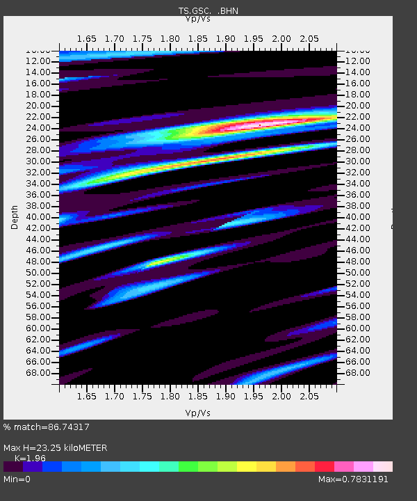
| Estimated Moho Depth: |
23.25 km |
| Estimated Crust Vp/Vs: |
1.96 |
| Assumed Crust Vp: |
6.276 km/s |
| Estimated Crust Vs: |
3.202 km/s |
| Estimated Crust Poisson's Ratio: |
0.32 |
|
| Radial Match: |
86.74317 % |
| Radial Bump: |
400 |
| Transverse Match: |
83.68652 % |
| Transverse Bump: |
400 |
| SOD ConfigId: |
17000 |
| Insert Time: |
2010-02-26 14:16:47.602 +0000 |
| GWidth: |
2.5 |
| Max Bumps: |
400 |
| Tol: |
0.001 |
|

Signal To Noise
| Channel | StoN | STA | LTA |
| TS:GSC: :BHN:19940822T17:38:30.825Z | 2.660079 | 2.824823E-7 | 1.0619319E-7 |
| TS:GSC: :BHE:19940822T17:38:30.825Z | 3.7249138 | 4.2414058E-7 | 1.1386587E-7 |
| TS:GSC: :BHZ:19940822T17:38:30.825Z | 21.884533 | 1.7607988E-6 | 8.04586E-8 |
| Arrivals |
| Ps | 3.6 SECOND |
| PpPs | 11 SECOND |
| PsPs/PpSs | 14 SECOND |


