You are here: Home > Network List > N4 - Central and EAstern US Network Stations List
> Station Y49A Blount Mountain, AL, USA > Earthquake Result Viewer
Y49A Blount Mountain, AL, USA - Earthquake Result Viewer
| Earthquake location: |
Near West Coast Of Honshu, Japan |
| Earthquake latitude/longitude: |
38.6/139.5 |
| Earthquake time(UTC): |
2019/06/18 (169) 13:22:19 GMT |
| Earthquake Depth: |
12 km |
| Earthquake Magnitude: |
6.4 Mww |
| Earthquake Catalog/Contributor: |
NEIC PDE/us |
|
| Network: |
N4 Central and EAstern US Network |
| Station: |
Y49A Blount Mountain, AL, USA |
| Lat/Lon: |
33.86 N/86.41 W |
| Elevation: |
362 m |
|
| Distance: |
96.2 deg |
| Az: |
36.941 deg |
| Baz: |
325.56 deg |
| Ray Param: |
0.040568102 |
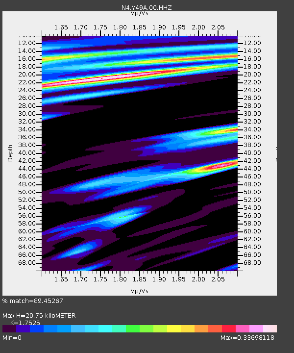
| Estimated Moho Depth: |
20.75 km |
| Estimated Crust Vp/Vs: |
1.75 |
| Assumed Crust Vp: |
6.565 km/s |
| Estimated Crust Vs: |
3.746 km/s |
| Estimated Crust Poisson's Ratio: |
0.26 |
|
| Radial Match: |
89.45267 % |
| Radial Bump: |
400 |
| Transverse Match: |
83.21109 % |
| Transverse Bump: |
400 |
| SOD ConfigId: |
18369291 |
| Insert Time: |
2019-07-02 13:30:11.025 +0000 |
| GWidth: |
2.5 |
| Max Bumps: |
400 |
| Tol: |
0.001 |
|

Signal To Noise
| Channel | StoN | STA | LTA |
| N4:Y49A:00:HHZ:20190618T13:35:15.280029Z | 8.118056 | 5.544133E-7 | 6.829384E-8 |
| N4:Y49A:00:HH1:20190618T13:35:15.280029Z | 2.1360347 | 6.444108E-8 | 3.0168554E-8 |
| N4:Y49A:00:HH2:20190618T13:35:15.280029Z | 1.6205974 | 1.0139806E-7 | 6.2568326E-8 |
| Arrivals |
| Ps | 2.4 SECOND |
| PpPs | 8.5 SECOND |
| PsPs/PpSs | 11 SECOND |


