You are here: Home > Network List > O2 - Oklahoma Consolidated Temporary Seismic Networks Stations List
> Station SC02 Maysville, Garvin & McClain Counties, OK, USA > Earthquake Result Viewer
SC02 Maysville, Garvin & McClain Counties, OK, USA - Earthquake Result Viewer
| Earthquake location: |
Near West Coast Of Honshu, Japan |
| Earthquake latitude/longitude: |
38.6/139.5 |
| Earthquake time(UTC): |
2019/06/18 (169) 13:22:19 GMT |
| Earthquake Depth: |
12 km |
| Earthquake Magnitude: |
6.4 Mww |
| Earthquake Catalog/Contributor: |
NEIC PDE/us |
|
| Network: |
O2 Oklahoma Consolidated Temporary Seismic Networks |
| Station: |
SC02 Maysville, Garvin & McClain Counties, OK, USA |
| Lat/Lon: |
34.80 N/97.39 W |
| Elevation: |
310 m |
|
| Distance: |
89.9 deg |
| Az: |
43.56 deg |
| Baz: |
319.028 deg |
| Ray Param: |
0.041708533 |
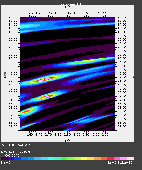
| Estimated Moho Depth: |
42.75 km |
| Estimated Crust Vp/Vs: |
1.73 |
| Assumed Crust Vp: |
6.426 km/s |
| Estimated Crust Vs: |
3.72 km/s |
| Estimated Crust Poisson's Ratio: |
0.25 |
|
| Radial Match: |
90.31285 % |
| Radial Bump: |
400 |
| Transverse Match: |
74.725235 % |
| Transverse Bump: |
400 |
| SOD ConfigId: |
18369291 |
| Insert Time: |
2019-07-02 13:30:58.538 +0000 |
| GWidth: |
2.5 |
| Max Bumps: |
400 |
| Tol: |
0.001 |
|

Signal To Noise
| Channel | StoN | STA | LTA |
| O2:SC02: :HHZ:20190618T13:34:46.424987Z | 8.263747 | 1.1134631E-6 | 1.347407E-7 |
| O2:SC02: :HHN:20190618T13:34:46.424987Z | 1.8362467 | 4.7248164E-7 | 2.5730836E-7 |
| O2:SC02: :HHE:20190618T13:34:46.424987Z | 1.328287 | 2.7586506E-7 | 2.0768483E-7 |
| Arrivals |
| Ps | 4.9 SECOND |
| PpPs | 18 SECOND |
| PsPs/PpSs | 23 SECOND |


