You are here: Home > Network List > TA - USArray Transportable Network (new EarthScope stations) Stations List
> Station B18K Kokolik River, AK, USA > Earthquake Result Viewer
B18K Kokolik River, AK, USA - Earthquake Result Viewer
| Earthquake location: |
Near West Coast Of Honshu, Japan |
| Earthquake latitude/longitude: |
38.6/139.5 |
| Earthquake time(UTC): |
2019/06/18 (169) 13:22:19 GMT |
| Earthquake Depth: |
12 km |
| Earthquake Magnitude: |
6.4 Mww |
| Earthquake Catalog/Contributor: |
NEIC PDE/us |
|
| Network: |
TA USArray Transportable Network (new EarthScope stations) |
| Station: |
B18K Kokolik River, AK, USA |
| Lat/Lon: |
69.36 N/161.80 W |
| Elevation: |
222 m |
|
| Distance: |
43.5 deg |
| Az: |
26.127 deg |
| Baz: |
256.585 deg |
| Ray Param: |
0.07252278 |
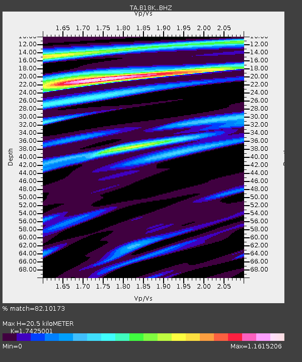
| Estimated Moho Depth: |
20.5 km |
| Estimated Crust Vp/Vs: |
1.74 |
| Assumed Crust Vp: |
5.906 km/s |
| Estimated Crust Vs: |
3.39 km/s |
| Estimated Crust Poisson's Ratio: |
0.25 |
|
| Radial Match: |
82.10173 % |
| Radial Bump: |
400 |
| Transverse Match: |
67.749016 % |
| Transverse Bump: |
400 |
| SOD ConfigId: |
18369291 |
| Insert Time: |
2019-07-02 13:32:37.884 +0000 |
| GWidth: |
2.5 |
| Max Bumps: |
400 |
| Tol: |
0.001 |
|
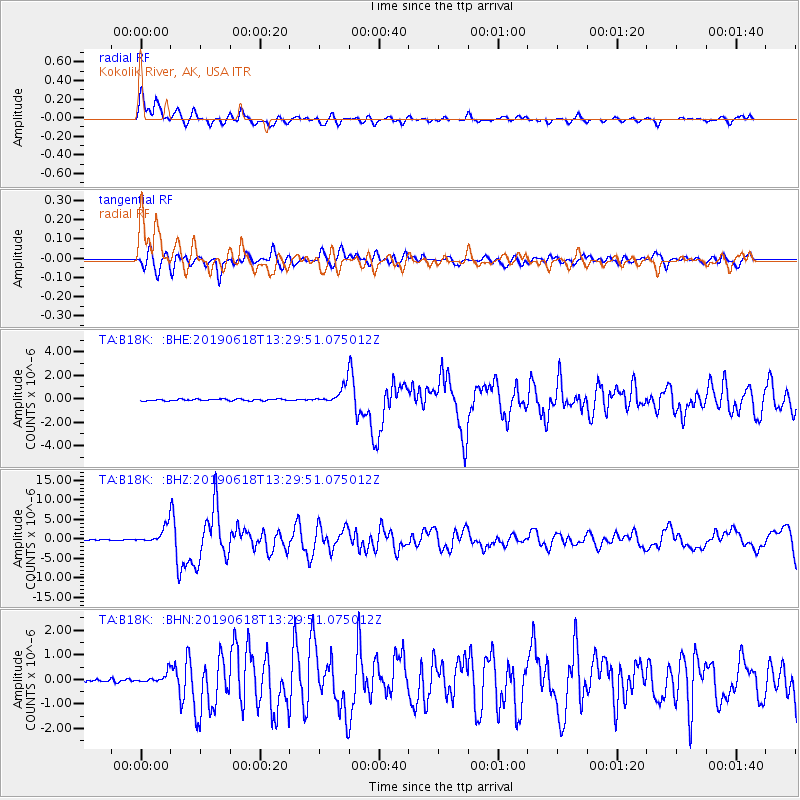
Signal To Noise
| Channel | StoN | STA | LTA |
| TA:B18K: :BHZ:20190618T13:29:51.075012Z | 22.040766 | 2.2072538E-6 | 1.00144156E-7 |
| TA:B18K: :BHN:20190618T13:29:51.075012Z | 2.843313 | 2.1066558E-7 | 7.409159E-8 |
| TA:B18K: :BHE:20190618T13:29:51.075012Z | 10.272314 | 7.500938E-7 | 7.302092E-8 |
| Arrivals |
| Ps | 2.7 SECOND |
| PpPs | 9.0 SECOND |
| PsPs/PpSs | 12 SECOND |


