You are here: Home > Network List > TA - USArray Transportable Network (new EarthScope stations) Stations List
> Station C17A Wharram Farm, Highwood, MT, USA > Earthquake Result Viewer
C17A Wharram Farm, Highwood, MT, USA - Earthquake Result Viewer

| Earthquake location: |
North Of Honduras |
| Earthquake latitude/longitude: |
16.7/-86.2 |
| Earthquake time(UTC): |
2009/05/28 (148) 08:24:45 GMT |
| Earthquake Depth: |
10 km |
| Earthquake Magnitude: |
6.7 MB, 7.2 MS, 7.3 MW, 7.3 MW |
| Earthquake Catalog/Contributor: |
WHDF/NEIC |
|
| Network: |
TA USArray Transportable Network (new EarthScope stations) |
| Station: |
C17A Wharram Farm, Highwood, MT, USA |
| Lat/Lon: |
47.63 N/110.76 W |
| Elevation: |
1080 m |
|
| Distance: |
36.8 deg |
| Az: |
332.081 deg |
| Baz: |
138.441 deg |
| Ray Param: |
0.076457135 |
| Estimated Moho Depth: |
38.0 km |
| Estimated Crust Vp/Vs: |
1.71 |
| Assumed Crust Vp: |
6.306 km/s |
| Estimated Crust Vs: |
3.699 km/s |
| Estimated Crust Poisson's Ratio: |
0.24 |
|
| Radial Match: |
97.99643 % |
| Radial Bump: |
293 |
| Transverse Match: |
88.57853 % |
| Transverse Bump: |
400 |
| SOD ConfigId: |
2648 |
| Insert Time: |
2010-03-07 00:05:58.731 +0000 |
| GWidth: |
2.5 |
| Max Bumps: |
400 |
| Tol: |
0.001 |
|
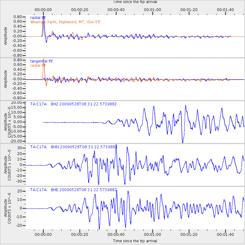
Signal To Noise
| Channel | StoN | STA | LTA |
| TA:C17A: :BHN:20090528T08:31:22.573988Z | 16.73308 | 1.1557476E-6 | 6.906962E-8 |
| TA:C17A: :BHE:20090528T08:31:22.573988Z | 6.9419255 | 6.3741714E-7 | 9.182138E-8 |
| TA:C17A: :BHZ:20090528T08:31:22.573988Z | 7.0601506 | 4.5074756E-7 | 6.3843906E-8 |
| Arrivals |
| Ps | 4.6 SECOND |
| PpPs | 15 SECOND |
| PsPs/PpSs | 20 SECOND |


