You are here: Home > Network List > UU - University of Utah Regional Network Stations List
> Station LCMT Little Creek Mountain, UT, USA > Earthquake Result Viewer
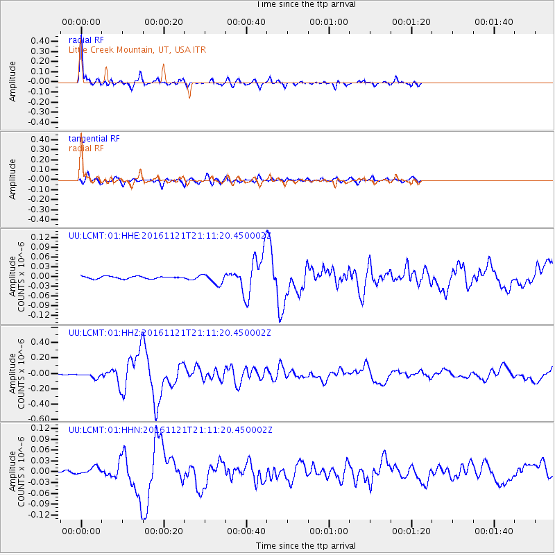
LCMT Little Creek Mountain, UT, USA - Earthquake Result Viewer
| Earthquake location: |
Near East Coast Of Honshu, Japan |
| Earthquake latitude/longitude: |
37.4/141.4 |
| Earthquake time(UTC): |
2016/11/21 (326) 20:59:49 GMT |
| Earthquake Depth: |
11 km |
| Earthquake Magnitude: |
6.9 MWB, 7.3 MI |
| Earthquake Catalog/Contributor: |
NEIC PDE/NEIC COMCAT |
|
| Network: |
UU University of Utah Regional Network |
| Station: |
LCMT Little Creek Mountain, UT, USA |
| Lat/Lon: |
37.01 N/113.24 W |
| Elevation: |
1411 m |
|
| Distance: |
78.8 deg |
| Az: |
51.885 deg |
| Baz: |
308.477 deg |
| Ray Param: |
0.049370218 |
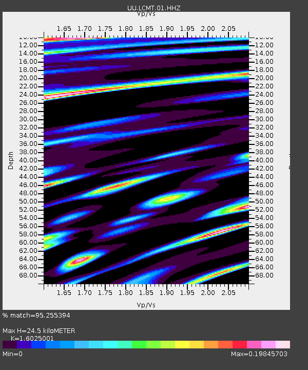
| Estimated Moho Depth: |
24.5 km |
| Estimated Crust Vp/Vs: |
1.60 |
| Assumed Crust Vp: |
6.194 km/s |
| Estimated Crust Vs: |
3.865 km/s |
| Estimated Crust Poisson's Ratio: |
0.18 |
|
| Radial Match: |
95.255394 % |
| Radial Bump: |
348 |
| Transverse Match: |
88.806274 % |
| Transverse Bump: |
400 |
| SOD ConfigId: |
1858631 |
| Insert Time: |
2016-12-05 21:06:25.672 +0000 |
| GWidth: |
2.5 |
| Max Bumps: |
400 |
| Tol: |
0.001 |
|
Signal To Noise
| Channel | StoN | STA | LTA |
| UU:LCMT:01:HHZ:20161121T21:11:20.450002Z | 9.390186 | 3.3847915E-8 | 3.604605E-9 |
| UU:LCMT:01:HHN:20161121T21:11:20.450002Z | 5.4072604 | 1.1488438E-8 | 2.1246318E-9 |
| UU:LCMT:01:HHE:20161121T21:11:20.450002Z | 4.6257224 | 1.6172821E-8 | 3.4962804E-9 |
| Arrivals |
| Ps | 2.5 SECOND |
| PpPs | 10.0 SECOND |
| PsPs/PpSs | 12 SECOND |


