You are here: Home > Network List > TA - USArray Transportable Network (new EarthScope stations) Stations List
> Station C17A Wharram Farm, Highwood, MT, USA > Earthquake Result Viewer
C17A Wharram Farm, Highwood, MT, USA - Earthquake Result Viewer
| Earthquake location: |
Hokkaido, Japan Region |
| Earthquake latitude/longitude: |
41.8/143.4 |
| Earthquake time(UTC): |
2009/06/05 (156) 03:30:33 GMT |
| Earthquake Depth: |
29 km |
| Earthquake Magnitude: |
6.0 MB, 6.3 MS, 6.4 MW, 6.4 MW |
| Earthquake Catalog/Contributor: |
WHDF/NEIC |
|
| Network: |
TA USArray Transportable Network (new EarthScope stations) |
| Station: |
C17A Wharram Farm, Highwood, MT, USA |
| Lat/Lon: |
47.63 N/110.76 W |
| Elevation: |
1080 m |
|
| Distance: |
69.4 deg |
| Az: |
44.048 deg |
| Baz: |
309.797 deg |
| Ray Param: |
0.05562856 |
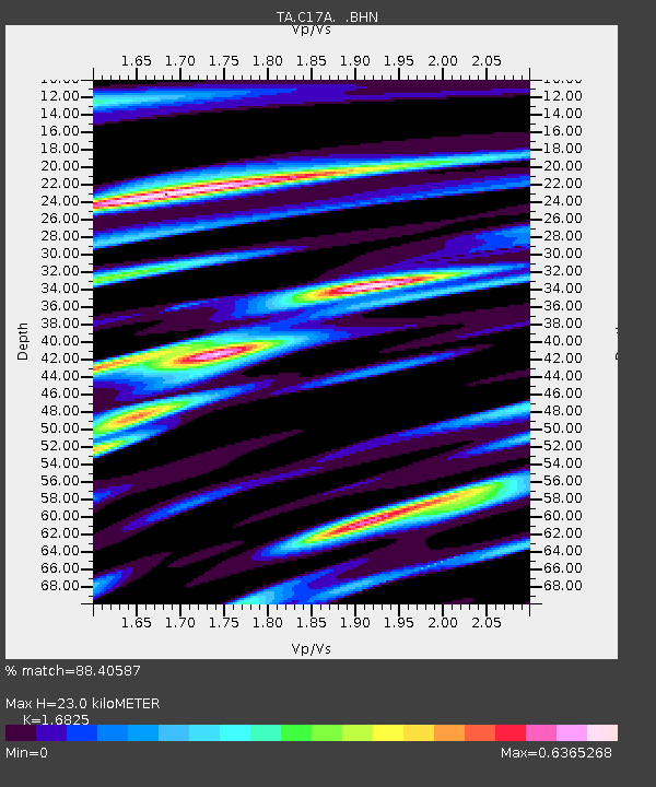
| Estimated Moho Depth: |
23.0 km |
| Estimated Crust Vp/Vs: |
1.68 |
| Assumed Crust Vp: |
6.306 km/s |
| Estimated Crust Vs: |
3.748 km/s |
| Estimated Crust Poisson's Ratio: |
0.23 |
|
| Radial Match: |
88.40587 % |
| Radial Bump: |
400 |
| Transverse Match: |
79.33154 % |
| Transverse Bump: |
400 |
| SOD ConfigId: |
2648 |
| Insert Time: |
2010-03-07 00:06:01.496 +0000 |
| GWidth: |
2.5 |
| Max Bumps: |
400 |
| Tol: |
0.001 |
|
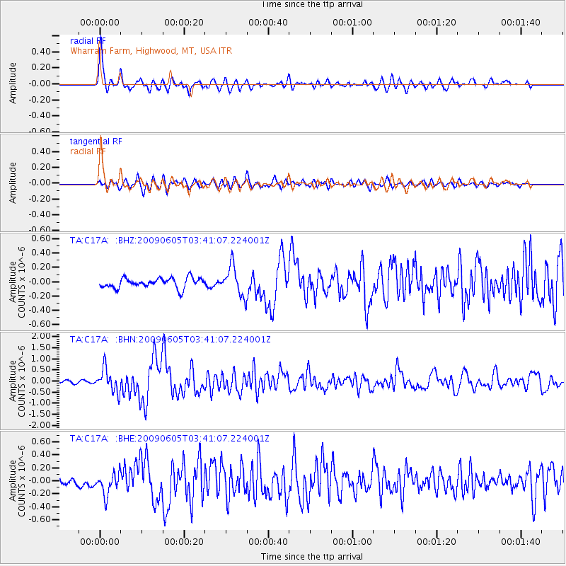
Signal To Noise
| Channel | StoN | STA | LTA |
| TA:C17A: :BHN:20090605T03:41:07.224001Z | 7.7911882 | 5.3392864E-7 | 6.852981E-8 |
| TA:C17A: :BHE:20090605T03:41:07.224001Z | 2.680768 | 1.6923218E-7 | 6.312825E-8 |
| TA:C17A: :BHZ:20090605T03:41:07.224001Z | 3.1333334 | 2.14912E-7 | 6.858893E-8 |
| Arrivals |
| Ps | 2.6 SECOND |
| PpPs | 9.4 SECOND |
| PsPs/PpSs | 12 SECOND |


