You are here: Home > Network List > TA - USArray Transportable Network (new EarthScope stations) Stations List
> Station D22K Ayikyak River, AK, USA > Earthquake Result Viewer
D22K Ayikyak River, AK, USA - Earthquake Result Viewer
| Earthquake location: |
Near West Coast Of Honshu, Japan |
| Earthquake latitude/longitude: |
38.6/139.5 |
| Earthquake time(UTC): |
2019/06/18 (169) 13:22:19 GMT |
| Earthquake Depth: |
12 km |
| Earthquake Magnitude: |
6.4 Mww |
| Earthquake Catalog/Contributor: |
NEIC PDE/us |
|
| Network: |
TA USArray Transportable Network (new EarthScope stations) |
| Station: |
D22K Ayikyak River, AK, USA |
| Lat/Lon: |
68.88 N/152.68 W |
| Elevation: |
532 m |
|
| Distance: |
46.6 deg |
| Az: |
27.501 deg |
| Baz: |
266.072 deg |
| Ray Param: |
0.07051916 |
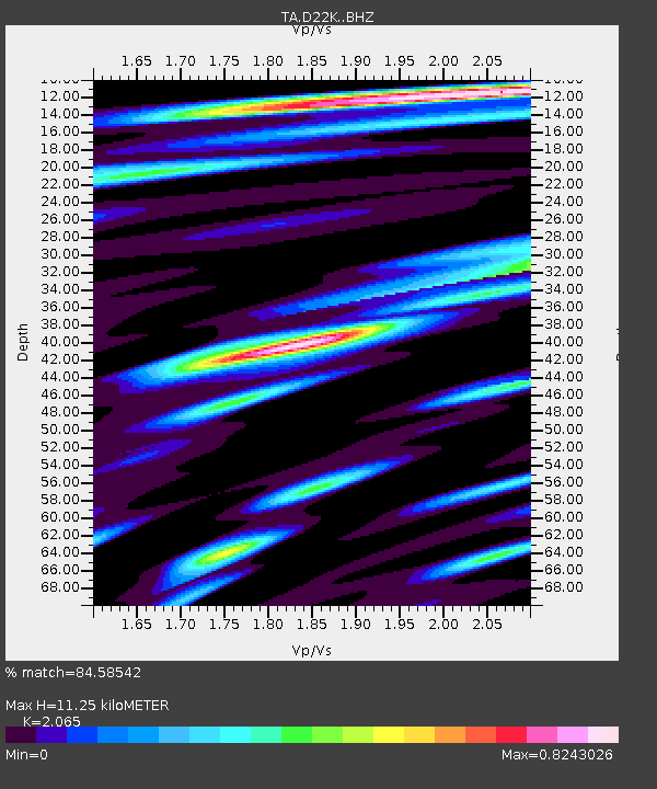
| Estimated Moho Depth: |
11.25 km |
| Estimated Crust Vp/Vs: |
2.07 |
| Assumed Crust Vp: |
6.221 km/s |
| Estimated Crust Vs: |
3.013 km/s |
| Estimated Crust Poisson's Ratio: |
0.35 |
|
| Radial Match: |
84.58542 % |
| Radial Bump: |
400 |
| Transverse Match: |
73.148834 % |
| Transverse Bump: |
400 |
| SOD ConfigId: |
18369291 |
| Insert Time: |
2019-07-02 13:32:49.420 +0000 |
| GWidth: |
2.5 |
| Max Bumps: |
400 |
| Tol: |
0.001 |
|

Signal To Noise
| Channel | StoN | STA | LTA |
| TA:D22K: :BHZ:20190618T13:30:16.125Z | 24.055342 | 1.8378595E-6 | 7.64013E-8 |
| TA:D22K: :BHN:20190618T13:30:16.125Z | 2.4384344 | 1.1236771E-7 | 4.6081908E-8 |
| TA:D22K: :BHE:20190618T13:30:16.125Z | 18.796516 | 8.057793E-7 | 4.2868542E-8 |
| Arrivals |
| Ps | 2.0 SECOND |
| PpPs | 5.3 SECOND |
| PsPs/PpSs | 7.3 SECOND |


