You are here: Home > Network List > TA - USArray Transportable Network (new EarthScope stations) Stations List
> Station C17A Wharram Farm, Highwood, MT, USA > Earthquake Result Viewer
C17A Wharram Farm, Highwood, MT, USA - Earthquake Result Viewer
| Earthquake location: |
Guerrero, Mexico |
| Earthquake latitude/longitude: |
17.0/-99.4 |
| Earthquake time(UTC): |
2009/04/27 (117) 16:46:28 GMT |
| Earthquake Depth: |
35 km |
| Earthquake Magnitude: |
5.7 MB, 5.4 MS, 5.8 MW, 5.8 MW |
| Earthquake Catalog/Contributor: |
WHDF/NEIC |
|
| Network: |
TA USArray Transportable Network (new EarthScope stations) |
| Station: |
C17A Wharram Farm, Highwood, MT, USA |
| Lat/Lon: |
47.63 N/110.76 W |
| Elevation: |
1080 m |
|
| Distance: |
31.9 deg |
| Az: |
345.457 deg |
| Baz: |
159.195 deg |
| Ray Param: |
0.078823 |
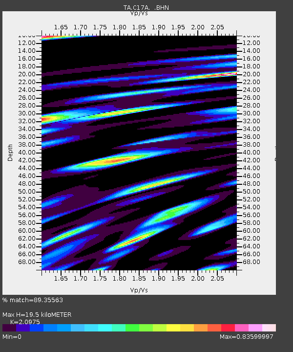
| Estimated Moho Depth: |
19.5 km |
| Estimated Crust Vp/Vs: |
2.10 |
| Assumed Crust Vp: |
6.306 km/s |
| Estimated Crust Vs: |
3.006 km/s |
| Estimated Crust Poisson's Ratio: |
0.35 |
|
| Radial Match: |
89.35563 % |
| Radial Bump: |
400 |
| Transverse Match: |
68.97738 % |
| Transverse Bump: |
400 |
| SOD ConfigId: |
2658 |
| Insert Time: |
2010-03-07 00:06:15.464 +0000 |
| GWidth: |
2.5 |
| Max Bumps: |
400 |
| Tol: |
0.001 |
|
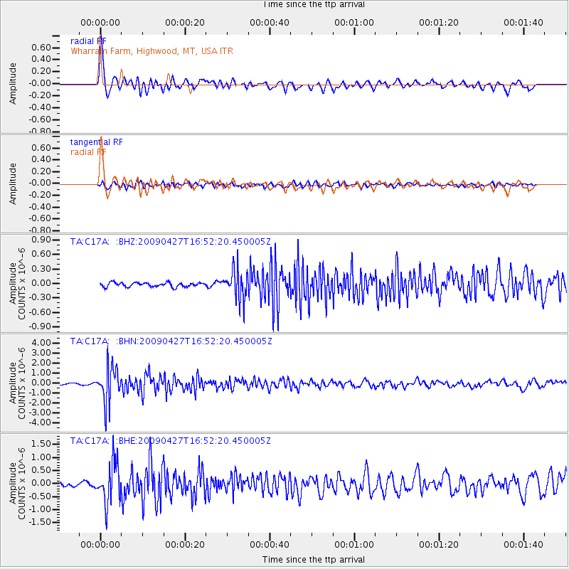
Signal To Noise
| Channel | StoN | STA | LTA |
| TA:C17A: :BHN:20090427T16:52:20.450005Z | 27.615532 | 1.7850805E-6 | 6.464045E-8 |
| TA:C17A: :BHE:20090427T16:52:20.450005Z | 10.653764 | 7.80872E-7 | 7.329542E-8 |
| TA:C17A: :BHZ:20090427T16:52:20.450005Z | 7.126667 | 3.0652438E-7 | 4.3010903E-8 |
| Arrivals |
| Ps | 3.6 SECOND |
| PpPs | 9.0 SECOND |
| PsPs/PpSs | 13 SECOND |


