You are here: Home > Network List > UU - University of Utah Regional Network Stations List
> Station NOQ North Oquirrh Mountains, UT, USA > Earthquake Result Viewer
NOQ North Oquirrh Mountains, UT, USA - Earthquake Result Viewer
| Earthquake location: |
Near East Coast Of Honshu, Japan |
| Earthquake latitude/longitude: |
37.4/141.4 |
| Earthquake time(UTC): |
2016/11/21 (326) 20:59:49 GMT |
| Earthquake Depth: |
11 km |
| Earthquake Magnitude: |
6.9 MWB, 7.3 MI |
| Earthquake Catalog/Contributor: |
NEIC PDE/NEIC COMCAT |
|
| Network: |
UU University of Utah Regional Network |
| Station: |
NOQ North Oquirrh Mountains, UT, USA |
| Lat/Lon: |
40.65 N/112.12 W |
| Elevation: |
1622 m |
|
| Distance: |
77.3 deg |
| Az: |
48.418 deg |
| Baz: |
308.461 deg |
| Ray Param: |
0.050440867 |
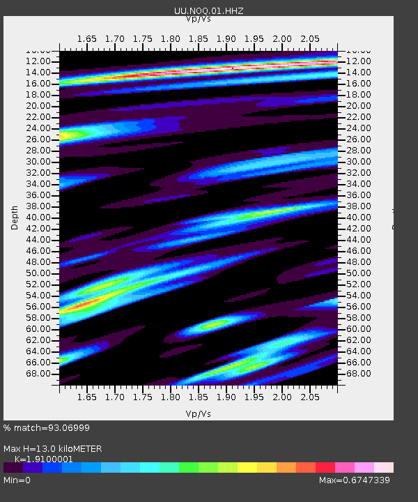
| Estimated Moho Depth: |
13.0 km |
| Estimated Crust Vp/Vs: |
1.91 |
| Assumed Crust Vp: |
6.276 km/s |
| Estimated Crust Vs: |
3.286 km/s |
| Estimated Crust Poisson's Ratio: |
0.31 |
|
| Radial Match: |
93.06999 % |
| Radial Bump: |
400 |
| Transverse Match: |
93.66124 % |
| Transverse Bump: |
384 |
| SOD ConfigId: |
1858631 |
| Insert Time: |
2016-12-05 21:06:32.575 +0000 |
| GWidth: |
2.5 |
| Max Bumps: |
400 |
| Tol: |
0.001 |
|

Signal To Noise
| Channel | StoN | STA | LTA |
| UU:NOQ:01:HHZ:20161121T21:11:11.734976Z | 9.040401 | 3.8432784E-8 | 4.2512256E-9 |
| UU:NOQ:01:HHN:20161121T21:11:11.734976Z | 2.5319226 | 1.1318683E-8 | 4.470391E-9 |
| UU:NOQ:01:HHE:20161121T21:11:11.734976Z | 1.5749136 | 1.099785E-8 | 6.9831447E-9 |
| Arrivals |
| Ps | 1.9 SECOND |
| PpPs | 5.9 SECOND |
| PsPs/PpSs | 7.8 SECOND |


