You are here: Home > Network List > TA - USArray Transportable Network (new EarthScope stations) Stations List
> Station C17A Wharram Farm, Highwood, MT, USA > Earthquake Result Viewer
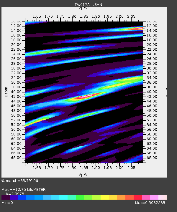
C17A Wharram Farm, Highwood, MT, USA - Earthquake Result Viewer
| Earthquake location: |
Guatemala |
| Earthquake latitude/longitude: |
14.6/-91.2 |
| Earthquake time(UTC): |
2009/05/03 (123) 16:21:47 GMT |
| Earthquake Depth: |
124 km |
| Earthquake Magnitude: |
5.6 MB, 6.2 MW, 6.2 MW |
| Earthquake Catalog/Contributor: |
WHDF/NEIC |
|
| Network: |
TA USArray Transportable Network (new EarthScope stations) |
| Station: |
C17A Wharram Farm, Highwood, MT, USA |
| Lat/Lon: |
47.63 N/110.76 W |
| Elevation: |
1080 m |
|
| Distance: |
36.8 deg |
| Az: |
337.732 deg |
| Baz: |
147.147 deg |
| Ray Param: |
0.076088 |
| Estimated Moho Depth: |
12.75 km |
| Estimated Crust Vp/Vs: |
2.10 |
| Assumed Crust Vp: |
6.306 km/s |
| Estimated Crust Vs: |
3.006 km/s |
| Estimated Crust Poisson's Ratio: |
0.35 |
|
| Radial Match: |
88.79196 % |
| Radial Bump: |
400 |
| Transverse Match: |
60.38466 % |
| Transverse Bump: |
400 |
| SOD ConfigId: |
2658 |
| Insert Time: |
2010-03-07 00:06:20.353 +0000 |
| GWidth: |
2.5 |
| Max Bumps: |
400 |
| Tol: |
0.001 |
|

Signal To Noise
| Channel | StoN | STA | LTA |
| TA:C17A: :BHN:20090503T16:28:12.225006Z | 13.910097 | 9.490995E-7 | 6.8230975E-8 |
| TA:C17A: :BHE:20090503T16:28:12.225006Z | 6.4613585 | 4.9531815E-7 | 7.6658516E-8 |
| TA:C17A: :BHZ:20090503T16:28:12.225006Z | 5.4549603 | 3.5082383E-7 | 6.431281E-8 |
| Arrivals |
| Ps | 2.4 SECOND |
| PpPs | 5.9 SECOND |
| PsPs/PpSs | 8.3 SECOND |


