You are here: Home > Network List > UU - University of Utah Regional Network Stations List
> Station PKCU Pink Cliffs, UT, USA > Earthquake Result Viewer
PKCU Pink Cliffs, UT, USA - Earthquake Result Viewer
| Earthquake location: |
Near East Coast Of Honshu, Japan |
| Earthquake latitude/longitude: |
37.4/141.4 |
| Earthquake time(UTC): |
2016/11/21 (326) 20:59:49 GMT |
| Earthquake Depth: |
11 km |
| Earthquake Magnitude: |
6.9 MWB, 7.3 MI |
| Earthquake Catalog/Contributor: |
NEIC PDE/NEIC COMCAT |
|
| Network: |
UU University of Utah Regional Network |
| Station: |
PKCU Pink Cliffs, UT, USA |
| Lat/Lon: |
37.44 N/112.31 W |
| Elevation: |
2834 m |
|
| Distance: |
79.1 deg |
| Az: |
51.068 deg |
| Baz: |
308.883 deg |
| Ray Param: |
0.049158357 |
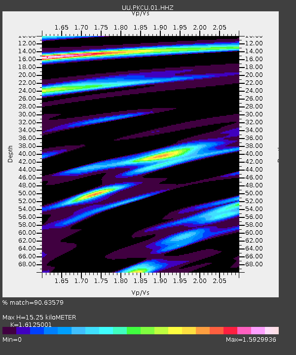
| Estimated Moho Depth: |
15.25 km |
| Estimated Crust Vp/Vs: |
1.61 |
| Assumed Crust Vp: |
6.194 km/s |
| Estimated Crust Vs: |
3.841 km/s |
| Estimated Crust Poisson's Ratio: |
0.19 |
|
| Radial Match: |
90.63579 % |
| Radial Bump: |
311 |
| Transverse Match: |
80.64844 % |
| Transverse Bump: |
400 |
| SOD ConfigId: |
1858631 |
| Insert Time: |
2016-12-05 21:06:34.573 +0000 |
| GWidth: |
2.5 |
| Max Bumps: |
400 |
| Tol: |
0.001 |
|

Signal To Noise
| Channel | StoN | STA | LTA |
| UU:PKCU:01:HHZ:20161121T21:11:22.169973Z | 9.396992 | 5.3235297E-8 | 5.6651426E-9 |
| UU:PKCU:01:HHN:20161121T21:11:22.169973Z | 0.8680657 | 1.6684202E-8 | 1.9219977E-8 |
| UU:PKCU:01:HHE:20161121T21:11:22.169973Z | 1.01862 | 1.3699221E-8 | 1.3448804E-8 |
| Arrivals |
| Ps | 1.6 SECOND |
| PpPs | 6.2 SECOND |
| PsPs/PpSs | 7.8 SECOND |


